このブログを検索:山名などキーワードを入れてください

2015-03-01

2015年2月28日 平溪薯郎尖 - 盤石嶺 - 菁桐古道 慢集團山行 Mt. Shulangjian - Panshiling hiking

The summit of Mt. Shulangjian
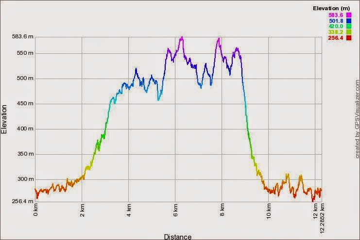
今回は、月一の慢集團の道案内山行である。二週間前今回案内のルート事前再確認を行い、この山行となった。比較的楽な山行である。前半の薯榔尖の登りと北稜をすぎれば、後半は良い道であり、盤石嶺の花見を兼ねての休憩後は菁桐古道を下るだけである。8時に出発し、午後3時には菁桐下って終了した。すでに日本語で記した登山記があるので、今回は英語での表記である。

-------------------------------------------------------

We start from Yikengkou (left) and come down to Jingtong Station (right)
Located in Pingxi district (平溪區) of New Taipei City, Mt. Shulangjian (薯榔尖) is one of the so-called three pointing peaks of Pingxi. Shulang is a plant which is original material to produce dye for fabrics in the past. The triangular shape of the peak resembles Mt. Fuji of Japan, particularly viewing from the old dormitories of Taiyang mining company where Japanese managers stayed and longed for their return to home. So they called this peak Pingxi Fuji. Mt. Shulangjian has three trails to reach its summit. One is from Erkenkou (二坑口) and this is a stone paved footpath all the way to the top. The second one is from Yikengkou (一坑口) is a dirt path and can be slippery after rain. The third one is a ridge route from the main ridge between Mt. Erkongguishan (耳空龜山) and Panshiling (盤石嶺). This one is pretty tough to walk as it has deep decent and steep accent coming one after another. If you have little hiking experience, you would better take the first one because it is really easy and avoid the third one.

All members of the hike
Panshiling, a name implies a peak of a mountain, but it is not. This is a saddle part of  the ridge and the lowest point where Xiping Road (汐平公路) passes through. There are many cherry tress around this pass and it is really good to rest here for lunch if the weather is fine. The cherry trees here blooms rather late in comparison with those at the food of mountains, because cold wind blows through and general climate is more hush here. Cherry blossoms are in full bloom in late February and early March.

#795 bus at Yikengkou bus stop
The hiking this time was to go up Mt. Shulangjian via the second trail from Yikengkou. We walked along its north ridge to the main ridge and then followed the main ridge to Panshiling. After we had lunch break at Panshinling for an hour and walked down to Jingtong, once an old mining town and now a hot tourist spot, via Jingtong old trail (菁桐古道). This hike was a mixture of thrill over the north ridge and joy of walking an easy old trail down after enjoying cherry blossoms. Under the event of Manjituang hiking club (慢集團), 38 of us walked this hike.

Climbing slippery rock section

Most of the participants gather at MRT Muzha (捷運木柵) station bus sop and takes a 795 bus at a little after 7:00. Approximately 40 minutes ride takes us to our starting point, Yikengkou bus stop. A few of our members have come by their own cars and join us here. After a brief explanation about the hiking course, we start at 8:03. The name Yikengkou means the first mine portal and there used to be a coal mining shaft in the valley. We pass those old houses of miners. They are in rather sad shape and present sharp contrast to those houses repaired and maintained as tourist attraction near Jingtong station. We come to the entrance of the footpath to Mt. Shulangjian in a few minutes.

Yikengkou route to Mt. Shulangjian in thick mist
The North Ridge route
The footpath is wet after rain of the day before. Weeds besides the path are all wet and bottom of your pants gets soggy quickly. We have a very young member among today's troop walking just behind me; a boy of 9 years old. His father is also in the troop walking just behind him. This boy has been to hiking at many places, according to his father, and is doing pretty good. The path goes among trees and passes over a concrete duct which is apparently an air duct for the abandoned mining shaft. We start a steep climb. Ropes appear where the incline is steep. Fog is pretty thick and you cannot see other peaks just across the valley on your left. We go over a slippery rock hump twice on the way up. At 9:08 we reach the top of Mt. Shulangjian. Though no rain it is in thick fog and there is sadly no view.

Mt. Shigongjishan and other peaks floating over the sea of clouds (Mr. Wang)
Passing a feeble looking branch bridge
The summit is pretty narrow and there is no room for all members to stand at one time. Before the rest of members come up, the front members start for the next section, the North Ridge. The path immediately descends and goes on a rather level ridge for a while. Fog is disappearing all the sudden and you have a view of sea of clouds beneath you. The peak of Mt. Shigongjishan (獅公髻山) of Pinglin (坪林) and its adjacent peaks are floating over the clouds like islands in the ocean. At 9:40 we start a pretty steep decent which lasts twenty minutes. At the bottom of the decent we pass a single wood bridge made out of a feeble-looking tree branch. It is kind of fun to pass over it though you have to be careful. Then we start a steep uphill. After a struggle of another 20 minutes  we come up onto the ridge. The section which we have just passed is to go around the rock cliff on the ridge, otherwise you have to climb down rock face, which is impossible.

Troop marching up and down through woods
This is a halfway point on the North Ridge and there is more ups and downs before reaching the main ridge trail. The weather is turning good. As we go up and down small peaks, the sun occasionally appears and welcome sunlight makes golden spots here and there on the ground among trees. We pass more of precarious spots and reach the main ridge trail at 11:30. It took us nearly two hours and 15 minutes from the peak of Mt. Shulangjian. I am glad that everybody has safely passed this dangerous section. After a short rest we head for our next stop, Panshiling.

Reaching the well maintained main ridge trail 
Spider web on side of the trail
In comparison with the North Ridge, this trail on the main ridge is just a breeze. It is well equipped and maintained. There are thick rope railings along steep sections. Weeds have been cut out and the trail is pretty clear and neat. There are also wood steps on  steep slopes too! Approximately 40 minutes of ups and downs on small humps along the main ridge bring us to Panshiling. The sun is now shinning above us and cherry trees are blooming on the side slopes of Panshiling. It is warm and comfortable. We take a long rest of one hour and have lunch. Members spread out to various spots where they find comfortable. Though about a half of cherry trees are not yet in bloom, it is still beautiful there.

View at Panshiling, the front is Xiping Road
Jingtong old trail and cherry blossoms
A junction on the old trail, we take right here
At 13:15 we start our last leg of today's hike, walk down along Jingtong old trail . This old trail used to be an important passage between Xizhi (汐止) and mining town Jingtong (菁桐). The railroad was constructed and completed in 1921 by Taiyang Mining Company only for transporting coal and later absorbed by the national railroad in 1929. It was however a long way from Jingtong to Xizhi by railroad so people walked this old trail to connect the two villages. We first go up a wide dirt road for a little while and pass Nikuitatouge (肉板峠). It is said that in old days there was a guard post here to watch the passage of people and goods going in and out of Jingtong. As a matter of fact the name sounds funny, meaning meat plates passage of the ridge.

The troop going down a steep downhill
Mosengzai Cave
Another cave
A little walk from Nikitatouge brings us to a junction where we take right. Wood steps lead up to a summit. Weeds have been cut out and the path is pretty clear. From the summit, we go down the dirt steep path. Some spots are pretty slippery. Many sacks filled with dirt are laid along the path. They form a kind of water drainage. We come down to a flatter section and soon see a cave on your left. It is called Moshenzai cave (魔神仔洞) but actually it is not a cave but a tunnel. There used to be a coal mine further up the valley and a rail track was to carry coal. The cave was a tunnel for the rail track those days. We go around the right side of the cave and come to a junction. Stone steps are paved on the trail further down and another to up to the left.

Looking over the bridge, Mt. Fengtoujia is in distance
Before we go further down the stone paved trail to Jingtong, we first go up to left side to see another cave. This second cave is also called Moshenzai cave and again actually is a tunnel. This tunnel is short and you can see light on the other end. The portal of the cave that we saw just a while ago is located on the left. We return to the junction and take left to go down. The stone paved trail is very good. After crossing a bridge over a stream we come to another junction at 14:30. If you take right here, you can go straight to Shuangjing Road (雙菁公路) . Those members who came to Yikegkou by their cars follow this right trail and go directly back to where they parked their cars. The rest of us take left and go down to a stream. Peaks of Mt. Fengtoujian are visible over the valley. Passing the bridge and we come to a junction where a path to Mt. Shisunjian (石筍尖)  diverges.

Overlooking JIngtong railway station
As we go along the last few hundred meters of trail we can see Mt. Shulangjian on our right. The triangle shaped peak is just up there where we were this morning. Passing old houses and we take left turn. Soon we arrive a flat yard just above Jingtong railway station at 14:50. A huge crowd of tourists are down there. A musician is playing songs very loudly. This is indeed another world to us who have just come through the tranquil valley. We swim through the crowd in front of the station house and go to the bus stop on Shuangjing Road. A crowded bus comes at 15:13 and we leave Jingtong for Muzha.

This is basically an easy hike covering only six kilometers, except the North Ridge of Mt. Shulangjian section. The total activity time is 7 hours including rest. The weather turned fine by noon and made us happily appreciate cherry blossoms at Panshiling. The level of the course is level 3 except the Shulangjian North Ridge being level 4. The physical fitness level is 3.
Cherry blossoms at Panshiling, Taiawn native cherry 

2015年2月25日 關西八寮古道 - 石門山縱走 樟脳の村を繋いだ古道

石門水庫から望む大竹坑山(左)と太平山
八寮古道の峠、左が八寮へ下がっていく道、右は稜線道
新竹県の関西鎮は、日本的な響きのある名前である。もともとの台湾語の音が日本語の関西に近いので、大正九年の行政区画整理の際に関西という名称がつけられそれが今まで続いているということだ。今は第三高速道路のインターチェンジもあり、山に遮られた過日の交通不便を思い知ることは難しい。しかし、当時は主要な産物の樟脳を運び出すにも峠を越えていく必要があった。龍潭と樟脳の村八寮をつなぐ道が、八寮古道である。当時は、いくつかの村があり、今でも四寮がある。十寮もあったそうだが今はない。八寮古道は、また十寮古道とも呼ばれる。

龍潭澹園から南へ、山を歩いて石門水庫へ
500m台の稜線歩き
八寮古道が越えていく峠は、以前訪れた石門山から南西に伸びる山並みの鞍部にある。今回の山行は古道を登り、峠からは石門山へ縦走するルートである。他の古道がそうであるように、当時は八寮古道は重要な道であったが、自動車道路ができた後は忘れ去れた。八寮古道の南側は、まだネット上の記録があるが北側の龍潭への部分は殆どない。唯一内容があるTonyの登山記録は十年前のものである。その記録をたよりに行ったが、途中は草が深くあるべき分岐もわからず、別のルートから稜線に上がった。はじめに稜線上を八寮古道のまで往復し、そこから十寮山、大竹坑山を越えて石門山へ縦走した。石門山からは石門水庫に下りた。ニュースで知っていたが、今年は雨量が少なくダムの水位はかなり低かった。給水制限の理由がうなずける。

龍潭と關西の間の山を歩く
亞聯客運1728番バスで台北を出発
龍潭は、台北から行く場合は第三高速道路に近いので、自動車で行けば一番便利だ。公共交通機関では、高速道路バスがある。亞聯客運の新竹行き1728番バスが、自宅近くのバス停を通り龍潭へも立寄るので便利である。龍潭の街から、八寮古道の登山口までは約10kmほど距離がある。そこでできるだけ近くまでということで、5049番バスで澹園へ向かった。ただ、このバス便は一日三便だけである。桃園客運龍潭バスターミナル7時35分発の便に間に合わないと、歩くかタクシーしかない。そこで自宅を6時半に出発、39分にやって来たバスに乗る。バスにはすでに前のバス停で乗車した同行者のBさんが乗っている。乗客はまだ我々二人だ。

県道から見る石門山
バスは羅斯福路を進んで乗客を乗せ、安坑インターチェンジから高速道路に入る。龍潭には7時35分ギリギリに到着、バスを下りて通り対面のバス停に向かう。5049番バスはすでにターミナルから通りにでてまさに発車のところで乗車できた。次回また行くことがあるかわからないが、1728番バスは一便前ので行くほうが良いだろう。5049番バスは20分ほどで、終點澹園につく。住宅の前にポツンとあるバス停である。道路の反対側は農園だ。支度をして8時に出発する。先に65号県道を進む。茶畑の向こうに石門山の姿が霧の中にかすかに見える。

台湾植物薬園入口


省道3乙線を渡り、対面の産業道路を進む。入口には小粗坑古道の道標がある。小粗坑古道を左にわけ、道は登りぎみになる。粗坑窯を過ぎる。建物の外にはたくさんの大小陶磁器が置いてある。8時32分、右に台湾植物薬園の入口がある。車が入れないように扉が閉じているが、Tonyの記録によればこの先から古道が始まるはずだ。扉脇から入り進む。数分道なりに登り、薬園の建物が集まる場所に来る。そのうち車がやって来た。この薬園の人のようだ。神農養生家の看板が付いている左側の一番下の建物の対面にコンクリ階段がある。これが古道入口だ。

土地公
道に落ちているスターフルーツ
入ってすぐ左に土地公の祠がある。この土地公はどのような由来で造られてのかは判らないが、他の古道脇でも見るものと同様の石造りのものである。もとの階段にもどり登っていく。廃棄された小屋が並んでいる。階段がきれ土の道になる。そのまま進むと、道の真中に建物が建っている。Tonyの記録には記載がない。しかし、それ以外に道もない。建物の中を通り過ぎ、反対側の出口すぐ前にある分岐を右にとり、登っていく。つづら折りになって登る道は、Tonyの記録にある。どうやらこの建物は、この10年間の間に新たに建てられたようだ。

雑草に覆われた古道
送電鉄塔脇をゆく
スターフルーツ(楊桃)が道に落ちている。見上げればたくさん木に実っている。誰も収穫しないようだ。ステンレスの水タンク脇を過ぎると、道の様子は俄然悪くなる。ほとんど誰も歩かないようで、雑草が行く手を塞ぐ。古ぼけた藍天隊の布製標識リボンがある。どれだけ以前のものなのか。入口から約30分ほどの登りで、前方にトタン屋根の建物が見える。壊れた木製の門もある。門をくぐると別の道に合流する。左に取り進む。送電鉄塔の下をゆく。前方から土地の人がやって来た。尋ねると、草深いが峠を越えて道があるという。ステンレスタンクの脇を過ぎる。このあたりに右へ下がっていく道があるはずだが見つからない。

展望台からの景色、中央の建物は崑崙藥用植物園、右の山は石門山、遠くは桃園方向だが霧で見えない
廃棄されたバンガロー
大きな建物が左に現れ、その脇をさらに進むと左から舗装路と合流する。桜が咲いている。この道をとりあえず進む。少し行ったところの右に、踏跡が右に入っていく。確認してみると下っていくように見えるが、はっきりしない。道をさらに登っていく。左下には、崑崙藥用植物園の建物が見える。石段が右側にある。どんなものか登っていみる。尾根上にあがりその脇にこれまた廃棄された小屋が並んでいる。以前はバンガローとして使われていたようだ。数戸の小屋の先には展望台がある。登ってみる。幸い霧が少し晴れて、石門山が望める。その左前方には桃園方向が見えるはずだが、霧で見えない。

泉仙殿、この少し前に山方向への道がある
稜線上分岐、鉄門の向こうから来た、右は十寮山へ続く
もとの道に戻り進む。そのうち下り気味になり、その先に泉仙殿がある。野良犬が数匹いる。右に道が分岐して山の方向へ進む。この道を取って歩く。少し回りこみ、10時3分に稜線の分岐に着く。鉄の門がある。出発点澹園から二時間である。八寮古道は前半半分しか歩けなかったので、とりあえず峠に向かって稜線を下る。まもなく峠に到着する。ここは稜線道との十字路になる。右に下っていく古道は、そこそこ幅がある。反対側八寮側は、狭い谷に下っていく。標高440mと記されている峠には、もともと大正年代に建てられた当時の新竹州新竹郡關西庄十寮と大溪郡龍潭庄を分ける境界コンクリ柱があったそうだ。しかし、今は新しい林務局の柱が建っている。どのような事由で置き換えられたのか知らないが、古跡がなくなるのは残念だ。

十寮山頂上
昭和四年の基石と筆車
峠から道を先ほどの分岐へ戻る。そこから急坂が始まる。道は雑木林の中を進む。そこそこ歩かれており、状態はよい。先ほどの八寮古道とは大差だ。10時30分、十寮山頂上(標高538m)につく。頂上には昭和四年と刻まれた基石がある。これは当時のもののようだ。反対側には内務局と刻まれている。しばし休憩する。

稜線上を大竹坑山へ進む
大竹坑山頂上、左に水槽が見える
稜線を進む。下って行き送電鉄塔を過ぎる。その先倒木のところから右に折れて稜線を進む。直進する道はあまり歩かれていないようだが、これは直接山腹を仁和道路へ続く道だ。稜線上には岩の狭い部分も現れる。11時、大竹坑山(標高550m、別名崇壢山)につく。周囲は茅藪だが、綺麗に刈られている。今年1月25日付けの新しい山名板が取り付けらている。桃園鐮刀隊が最近この稜線道を整理したようだ。こうしたボランティアのお陰で、楽に縦走できる。頂上の脇には何故か水槽がある。

仁和道路上の石門山登山口
石門山への道から分岐部を見下ろす
数分くだっていくと、仁和道路が現れる。この道は、時々車が通り過ぎるが気にならない。左に下っていく。11時15分石門山登山口に着く。わきには太元九龍門總會の石碑がある。入口から広い車道をわずか二、三分進むと、左に山道が登っていく。これは、小粗坑山へ続く道だ。急な山道を登る。11時27分、小粗坑山頂上に着く。山道を下り11時35分、車道へ下りる。ここは、小粗坑古道の分岐でもある。道の脇に休憩所もある。

急坂を石門山へ登る


ここから、石門山への山道が始まる。石門山は多くの登山者が登っているので、先ほどの山道とは土の道だがレベルが違う。急な坂を上り詰め、11時46分に頂上に到着する。二度目の訪問だ。小百岳に選ばれているだけあって、平日だが数名の登山者が休んでいる。今日前半の山道とは対称的だ。ベンチに座り食事をとり、ゆっくりと休む。午前中は天気が良くなるように思えたが、雨は降らないものの霧は晴れずに展望はない。寒暖計は16度を示している。

ハイカーの多い石門山頂上
夫婦岩
12時10分、太平山に向けて歩き始める。石門山は道が多い。左の道を下る。夫婦石を通り過ぎる。ただ、この道は以前歩いたことがない。確認するとこれは直接麓に下る道で、少し戻り右に道を進む。労工育楽中心への道の鞍部に着く。稜線上を進み、景春歩道の鞍部を過ぎる。右に太平山を巻いて環湖公路へ続く道をわけ、急な斜面を登る。黒の子犬が下ってきてすれ違う。12時28分、大平山の頂上に来る。鉄塔の脇を過ぎ、右に道をわけ好漢坡の上部にくる。この道は急坂が続くので好漢坡と呼ばれている。日本ではさしずめ男坂といった名前の坂道である。土の道は滑りやすい。補助ロープもある。13時、坂道を下りきり山腹をやってくる道と合流する。左にとり、13時12分石門山登山道北端口に下りきる。

好漢坡
楓の林
石門水庫から龍潭を通る5055番バスが14時27分に発車する。まだ時間が十分ある。車道を右にダム堤防へ向かう。ゆっくりとした上り坂が続く。この周辺は楓林である。まだ葉が生えておらず、枝のままの姿だ。20分ほどやってくる。展望台がある。螺旋階段を最上階まで登る。ダム堤防の向こうに溪洲山が控えている。石牛山はわかるが、遠くの山はぼんやりしている。ダム工事の殉職者記念碑を過ぎ、堤防の上を進む。右の湖面ははるかに下で、水位が通常より数メートル低い。台北市ではあまり感じないが、今年は干ばつである。給水制限も行われている。堤防上から振り返れば、歩いてきた大竹坑山と太平山が並んでいる。堤防を渡りきり14時過ぎ、バス停に到着。14時30分、5055バスはやってきた。龍潭ではあまり待たずに台北行き1728番バスに乗り継ぎ、16時過ぎに台北に帰ってきた。

展望台上からの眺め
石門水庫
歩行距離約12.3km、行動時間6時間である。八寮古道を全部歩けなかったのは残念だった。しかし、ネット上にほとんど資料がないというのは、ほとんど歩かれていないことの証であったわけだ。峠から下れば様子は判るだろうが、それはチャンスが有ればまたの機会である。十寮山や大竹坑山は、最近桃園鐮刀隊が整理したこともあり、状態はよい。クラス3である。石門山付近はもっと状態がよい。体力的にはクラス3である。石門山以外は、人気のある場所ではないが、昭和四年の基石など日本時代の名残がある。峠の境界柱がなくなってしまっていたのは、実に残念だ。

2015-02-26

2015年2月21日 春節登山汐止大尖山 大尖瀑布から登り頂上で花見 Mt. Dajianshan: a short new year hike for cherry blossoms and wine

The largest waterfall on the route; a rope is visible besides water but we go pass around this one
台湾のお正月は旧暦で行われている。太陽暦に対しては毎年その時期がずれる。今年は比較的遅く2月19日が元日である。日本のお正月と同じようにこの前後は休日となり、日常業務は停止する。家族が集まりご馳走をいただくなど同じである。この旧暦正月中の一日に、台北近くの山に登りちょうど咲き始めた桜の花見を行った。花見には酒はつきものである。頂上でワインを飲んだ。

旧暦正月は、当然人口大移動である。高速道路は過去最高の交通量を記録、どこへ行くにも大変だ。そこで、今回の登山対象は近くでなおかつ花見ができる、またお酒を飲んだあとも簡単に下山できるところ、といった条件で選んだ。ただ、普通の道では面白く無いので、大尖山登山道の中で一番難度の高い大尖瀑布の道から登った。

大尖山は過去に何度か訪れその都度このブログに日本語で記述しているので、今回は英語で記載する。

----------------------------------------

A view from Mt. Dajianshan: looking for the direction of Taipei and the 101 building is visible
The lunar new year this time came rather late relative to the Gregorian calendar. Native Formosa cherry blossoms have already gone at many places by this time, while those on higher locations or in hash conditions just start blooming and I know that the cherry trees on the top of Mt. Dajianshan of Xizhi district, New Taipei City would bloom in late February. I didn't feel like to go strenuous hiking in the festive time so this was it. Highways and long-distance trains during the few days of lunar new year holidays are jam packed and it is not wise to go to faraway places. Mt. Dajianshan is just fifteen-minute-train-ride away from Taipei main station. It has a rather difficult route to go up while a stone paved trail is also available. So I decided to go up by this hard route of Dajian waterfalls, have fun with wine and cherry blossoms and walk down via an easy roue of stone paved trail.

A round trip around Mt. Dajianshan
The Dajian waterfall trail starts here
Some of my regular company went to their home in southern Taiwan but some friends staying in Taipei joined this hiking. We meet at a bus stop of  F911 community bus across Xizhi station. Two of them did not show up by 9:00 when the bus left and they catch us up by taxi near our starting point, Fuji Hilltop Community. We start at 9:20 and first go through the community houses along a street. We come out of the community in ten minutes and go around the foot of Mt. Dajianshan. We can see its top at some corners. There are a few cherry trees along the road, but most of the blooms have already gone. It is warm here and its blooming time is almost over by now.

The first waterfall: we climb the right dart slope
Cross the stream to the opposite side
At 9:40 we arrive at an entrance of Dajian waterfall trail. It is just at the elbow of a hairpin curve and stone steps are leading upwards. The footpath looks OK for the first few minutes but when we reach the first waterfall, we know that we have to climb a steep dart slope next to the waterfall. There should have been stone steps in the past but apparently a landslide washed them away. There are ropes affixed along the slope and they are useful. We keep going up like this for 15 minutes passing three waterfalls then see stone steps again. We go down to the bottom of the stream just in front of another small waterfall and cross the stream to the opposite side. As we come closer to a high waterfall in front of us, a vertical rock section faces us. We climb over it and find yet another very tall waterfall up there. The time is a quarter past ten. We have come for a half hour on this waterfall trail.

Climb the steep rock face
A thin rope is dangling besides falling water of the tall waterfall and it may be possible to climb the waterfall with aid of the rope. We do not dear to try it and start a go-round detour path on the right side. This path goes rather long way to pass the waterfall, but obviously much safer. We go up another very steep slopes and then traverse for the right direction, away from the stream. We have a short rest at a halfway point of this whole trail. It is 10:25 and we have walked for an hour by now. After a few minutes of rest, we resume our climb. The path now changes the direction and goes towards the stream. As we go along a level traversing path, we can see a view of the town down there. At 11:00 we come to a last waterfall of all. This one is not big, but we need to climb just besides running water.

Walking a traversing section
After we go up the top of the waterfall then we start a final steep ascent to the ridge above. We reach the wide hiking trail on the ridge at 11:38, the end of this climb. A man is just near where we pop out and wonders where on the earth we come from. The entrance of our path is not obvious and there is no sigh or any other indication. Unless you are familiar it is hard to identify there is a footpath. We turn right and head for the peak of Mt. Dajianshan. We find cherry are in bloom here and there on the sides of our trail. We reach the peak at 11:48. There are many hikers up here. The sun is shiny and sky is blue. Cherry blossoms here are just 30% in bloom because the condition is hush as cold wind blows through. It would need another week or so for all cherry trees come in full bloom. We have a long rest here under the warm sun with wine and food that members have brought up.

Looking over the town from a traversing path
The members going on a level traversing path
The last waterfall on the route
A final labor to the ridge
About a third of cherry on the summit are in bloom
We enjoy nearly two hours of lunch and start descent. We take a stone paved trail down. Though this is rather steep it is very safe with handrails. Even small kids are coming up too. We reach Tianxiugong temple at the end of trail. The place is full of people as today is a sunny holiday with cherry blossoms. We then take stone steps from Tenxiugong temple down to another temple Wugujinshengdian where a F911 bus stop is. On weekend and holidays, F911 only comes up to this place, not to Tianxiugong temple. As soon as we arrive there at 14:15, a bus comes and we take it down to Xizhi station.

Looking back the top of Mt. Daianshan on the way down
We walked for three hours this time. This was a short and easy hiking, though the trail up to the summit is not for everybody. The Dajian waterfall trail is not for beginners. The path is pretty clear and you will not lose it, but you have to have some experience of rope/rock climbing. The difficulty is level 3 in total, but if only take the waterfall trail, it is level 4. Stamina level is 2.