|
| 設置されたばかりの梯子 New aluminum ladder |
2016年に一度歩いた
平溪區の基隆河南岸にある小山を再度訪れた。位置的にはちょうど鉄道平溪線の十分駅~望古駅間の南側一帯になる。高度的には400mほどで、取るに足りなような小山であるが、実は峰々をつなぐ稜線上には大きな落差の岩壁などがあり、気楽なハイキングコースではない。つまりは、短いがそれなりに心構えをしていかないと、面食らうコースである。鉄道側から望むと、大きな岩壁が露出している山塊である。
九年前に歩いた時は、ほとんど歩かれていないこのルートが整備され、藪漕ぎなどの苦労なしで登れた。その後、また草木にふさがれそして、この一、二か月間にまたボランティアによって、草刈やロープの設置、そしてアルミの立派なはしごも取り付けられた。そこで、今回は九年前の逆コースで訪れた。その場合は、先にコース中の最高点に登り、次第に高度を下げていく形である。コース的には、方向の違いはあるが、主要部分は同じなので英語で記述する。
 |
| 司公碗帽山山頂,at Sigongwanmao-shan summit |
------------------
Pingxi district (平溪區) of New Taipei Municipality (新北市) is packed with mountains and hills. Its geography is spread out along Jilong River (基隆河) and tributaries . It once was dotted with coal mines, small and large, throughout the district. Those coal mines have long gone, and the mine towns were decimated until a decade or so ago when tourism revitalized the sleepy towns. Now tourists flock to towns of Xifen (十分), Pingxi and Jingtong (菁桐).
 |
| Hike from west to east |
The author has visited this district dozens of times for hiking since 2011. This trip added one more record to my visiting list. The destination for this hike is small peaks on the southern bank of Jilong River near Wanggu (望古). The peaks there are not popular at all while there are a dozens of peaks well visited in the district like Shifen-shan (十分山), Jiangzilia-shan (姜子寮山) and so on. They are not high and without good trails except right after volunteers make maintenance. I visited them in 2016 right after trail maintenance was done. Since then the trails have been claimed back by the nature and buried under thick weeds again. However they have recently been brought back by volunteers, and even with a permanent aluminum ladder! That motivated me to visit again. Our route was almost same except in the reversed direction.
 |
| A view of our hiking peaks through a train window |
Travel from Taipei to Pingxi by public transportation can be done via two routes. One from Muzha (木柵) via #795 bus service; the other by rail. It takes less time by bus if the destination is closer to Jingtong while probably same to Shifen depending on connection at Ruifang (瑞芳) on the main line. I mostly take #795 bus but I rode a train on my way back because the hike completed very early.
-------------------
 |
| Muzha zhan |
I took a #795 bus from its originating terminal Muzha zhan(木柵站). This name sounds similar to MRT Muzha station (捷運木柵站), but they are different and far apart each other. #795 buses call at MRT Muzha station and it may be confusing if you are new to the bus service. The service is at an hour interval for weekdays except morning or evening. Tourists as well as hikers like us ride #795s so that the buses are very often with no seats if you aboard midway.
 |
| Our bus leaving Wanbaodong stop |
 |
| Turn to the right road from #106 |
My bus left Muzha zhan at 7:10 with a few passengers and soon it was filled up. By the time it reached MRT Muzha zhan, the seats were all taken and with a few standing passengers. A ride of 70 minutes brought four friends and me to Wanbaodong (萬寶洞) bus stop, which I visited two times already this year. Another friend who came by train joined us there.
 |
| Covered with debris |
 |
| Walking along Huiyao road |
We stared at 8:28 and stepped onto a narrow road diverging from #106 road. When we came up a little to a junction, our trail to the left is covered with debris of rocks. This landslide must have been caused by heavy rain in a few days ago. We went over the debris and followed the trail to meet Huiyao road (灰窯產道). We walked about a half kilometer and found our obscure trail head.
 |
| Trail head |
 |
| Steep climb with ropes, old and new |
 |
| Duck under a fallen trunk |
The trail head is just a gap by a concrete retaining wall. If you are not careful you would not notice it. A short climb brought us onto a narrow ridge. The trail is pretty steep. New white ropes are fixed in addition to the old gray ones. As we went up for a half hour we could make out our first peak, Sigongwanmao-shan (司公碗帽山, or 石後山) through tree branches. At 9:18 we got onto a ridge coming from Mt. Huiyao-shan (灰窯山). A new direction sign says that the section for Huiyao-shan has not been maintained and you are recommended not to enter.
 |
| The summit is visible through trees |
 |
| Junction on the ridge from Huiyao-shan |
 |
| Last climb to the summit |
The ridge trail first dips to a bottom and climbs back to reach the summit of Sigongwanmao-shan (elevation 445 meters). Another friend were there waiting for us. He said that he came through the trail via Huiyao-shan and the trail was indeed not good. Two wooden benches are there by stone marker. Bushes and grasses around the summit are cleared, offering a good view towards Shifen town and a long mountain range behind. We even could make out a distinctive pyramid of
Mt. Jilong-shan (基隆山) in a far distance.
 |
| Summit of Sigongwanmao-shan |
 |
| A view from the summit |
 |
| Our next peaks are visible |
After twenty minutes of rest on the summit, we resumed our hike at 9:58. The sun is strong today, but a nice wind is blowing as long as we stay on the ridge. This section from the summit has been maintained very lately and easy to walk. Beyond a steep downward grade our next peaks, Nanshanping-shan (南山坪山) and Pinghujian (平湖尖) are visible.
 |
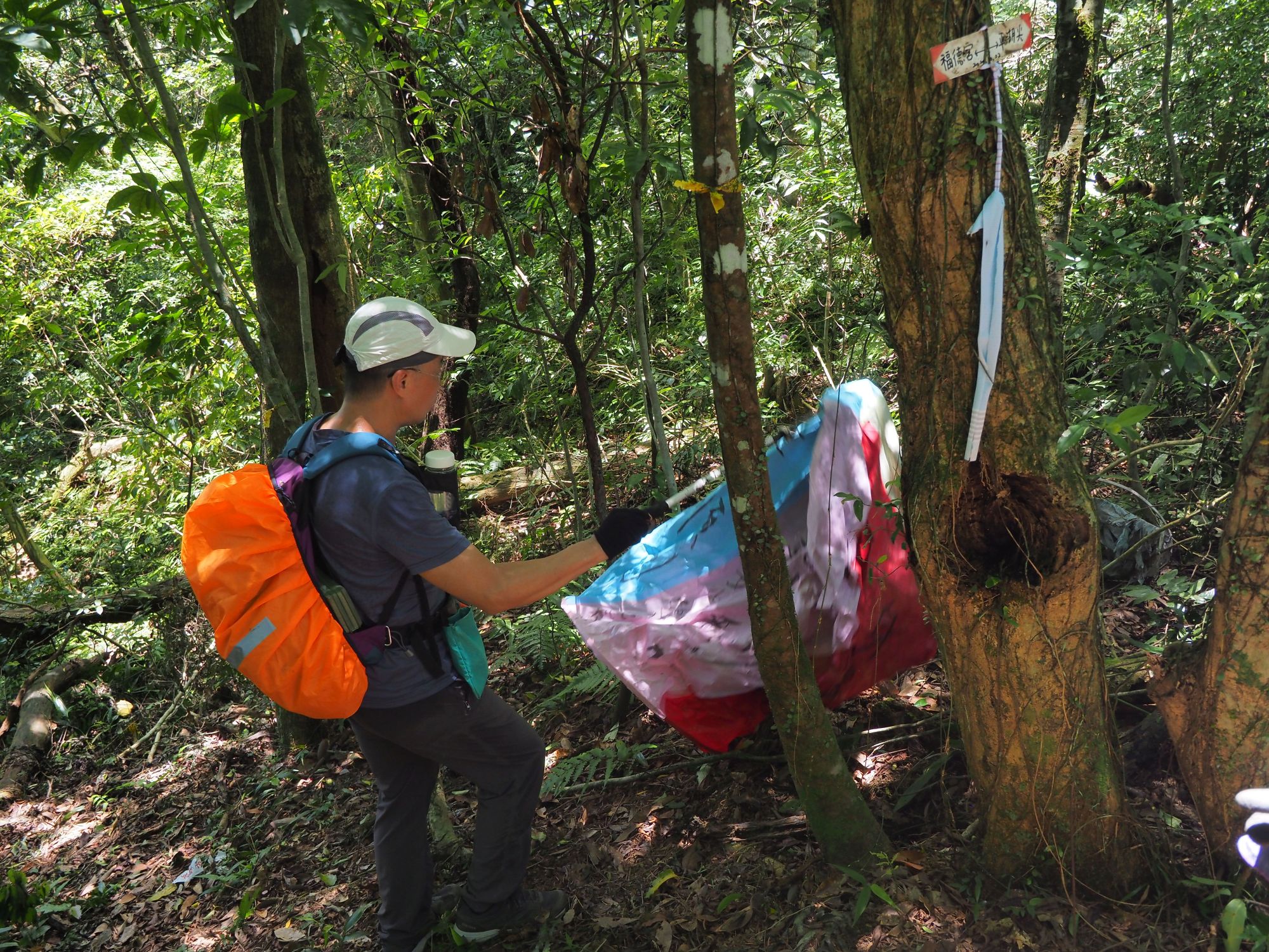
| Flying marker indicative of wind |
 |
| Trail passing by an electric tower |
In twenty minutes we have come down to a junction to marge a trail from right and then another junction of an electric maintenance path (保線路). Further along the ridge trail come up a shining aluminum tall ladder. This is the one that the volunteers fixed only a few days ago. They are firmly attached to the rock surface with professional skill. This cliff is 6 or 7 meters high and in the past we had to go up or down by a vertical gutter next to the new ladder. This ladder would give more safe passage for this cliff.
 |
| A junction |
 |
| Firmly fixed to the rock |
 |
| Ropes going all way around the rocks |
 |
| Rocky ridge section |
Passing more rock sections with ropes we came to a junction to Nanshanping-shan at 10:38. Its summit (elev. 395m) is off this ridge line and we made a round trip to it. The trail first goes down a bit and climbs with a very steep grade. The summit is pretty narrow, from which we can see Mt. Sigongwanmao-shan and the ridge extending over here.
 |
| Junction for Nanshanping-shan |
 |
| A view from Nanshanping-shan summit |
 |
| Vertical cliff to climb |
We followed the ridge trail after coming down from Nanshanping-shan and hit another vertical cliff. Ropes and wooden steps are fixed to the cliff, which you need to climb carefully. Up we went and reached the summit of Pinghujian (elev. 402m). Across the deep gap stands a rocky peak of Mt. Pinghu-shan (平湖山). It is so close yet you need to go down first and climb back again if you want to stand on its summit. With frequent nice breeze we had a lunch on the summit. A lone hiker came up while we were there. He is the only person we came across during the hike.
 |
| Pinghu-shan across a deep gap |
 |
| Having rest on the summit |
 |
| Steep descent |
At 11:40 we left the summit and descended a long and steep stretch to the bottom. A short climb back led us to a hump and again further down to a junction for bat cave (蝙蝠洞). We made a short detour to the cave. It is a huge but there is no bats there. Returning to the trail we went further down to a junction for Mt. Pinghu-shan. Its trail is obviously left untraveled for a long time. Weeds cover its track. So we gave up to climb to the summit and went further down.
 |
| Countless waste of sky lanterns (天燈) seen on our hike |
 |
| Bat cave 蝙蝠洞 |
 |
| Junction for Pinghu-shan |
 |
| Trail head |
As we walked down, the trail got wider. At 12:30 the trail ended by a green steel-sheet walled storage hut. We hurried down to the 106 road and caught our #795 bus, which came only in a minute after we reached Fudegong bus stop (福德宮站). The bus seats were all taken with a few standing passengers.
 |
| Fudegong bus stop on #106 road |
 |
| Jingtong bus stop |
I alighted at Jingtong bus stop. It was still very early so I decided to take a train back home. Through so called old street (老街) I went to Jingtong train station. It is a long time, at least several years, since I last visited this place. The station has been renovated and painted white. There are not so many tourists around but the fact that many shops are in business indicates tourism is thriving.
 |
| Jingtong train station |
 |
| Train at Jingtong soon to depart |
In a few minutes came a train of three diesel coaches. The train departed at 13:10, moving slowly down along the Jilong river. Through the window saw the peaks of our hike across the river near Wangu station. At Shifen station a bunch of tourists came aboard and instantly filled the train. At Ruifang station I got on board Puyoma-hao express train (普悠瑪號) after a half-hour layover. My train arrived at Taipei at 15:20.
-------------------------
 |
| Puyoma-hao express at Ruifang |
It turned out a short but exiting hike. It was fun, indeed. The distance was a little less than 4 kilometers. We spent 4 hours including breaks. The toral ascent was 410 meters, which is rather much for a short hike of this length. I really appreciate those volunteers for attaching such a nice ladder and other maintenance work. The ladder should stay for long, so I encourage hikers to visit this route. It is worth a try😊