|
北稜角から聖稜線を望む、Holy Ridge seen from the summit of Mt. Beilengjiao
|
雪山山脈の主要ピークは過去にだいぶ歩いた。今回歩く
聖稜線は、数年前に北から南に向け一度歩いた。その聖稜線を再び訪れた。ただルートは全く同じではなく、南の雪山主峰から北に向けて歩き、布秀蘭山から聖稜線を離れて東へ
武陵四秀の品田山と池有山を越えて下山し、武陵の登山口へと戻るものである。前回の縦走は、一般にI型聖稜線縦走と呼ばれ、今回の歩きかたはO型縦走といわれる。つまり今回の縦走は、世紀の奇峰大霸尖山には訪れていない。
今回の縦走にあたり、時間的に余裕を持ちゆっくりと台湾の高山を楽しむことを考えた。自分の68歳という年齢を考えると、今後高山の縦走をどれだけできるかわからない。もちろん続けていきたが、再び訪れることがないということを念頭に、そうした登山を心掛けた。幸い天気には恵まれ、ゆっくり過ごせた山頂から、或いは縦走途中から、雪山山脈や中央山脈だけでなく、今まで歩いた周囲の中級山の峰々などを、脳裏に焼き付けた。
 |
| 品田山より見る聖稜線南半分, The southern half of the Holy Ridge seen from Mt. Pintian-shan |
聖稜線については、前回の山行記録で記述しているので、ここでは改めて触れない。ただ、日本の富士山よりも高い台湾最高の縦走路を行く、聖稜線は日本の登山者に多く訪れてもらいたいと思う。台湾のアルピニズムを開いた日本人先輩たちがあこがれを以って望み、そして登頂した峰々を歩く、或いはそれを望むということを、今の日本人登山者にも体験してほしいと思う。
----------------------------------
 |
| Walked clock wise from the Xue-shan trail head to Wuling Villa |
Holy Ridge, it sounds religious. It is so in a sense, because it gave sacred impressions to those early alpinists of Taiwan's high mountains. One of such alpinists was Numai Tetsutaro (沼井鉄太郎 1898 - 1959) When he made the first climb in history to the summit of Mt. Dabajian-shan (大霸尖山) in 1927, he was so awestruck that he left such a remark in his article of Taiwan Alpinists magazine (台灣山岳 1928): "...Holy Ridge! I wonder who would ever succeed in traversing the entire ridge between Daihasen-san (大霸尖山 in Japanese) and Tsugitaka-yama (次高山, Xue-shan name of the time), get a glory and tell what it is like..." So was named this ridge, which happens to be the highest of all ridges of Taiwan mountains. The first successful traversing over the Holy Ridge was carried out by Inoue Kazuo (井上一男) and his group in 1931.
 |
| Cuichi pond reflecting the evening Holy Ridge |
Alpinism of Taiwan was brought by the Japanese during the Japanese reign over Taiwan. Japanese alpinism was born in Meiji era of Japan (明治時代1868-1912). Climbing mountains was of course normally done prior to that time. They climbed mountains for worship or livelihood like hunting, logging or such, but not for its own sake like hiking. When Japan opened its door to the world again in the Meiji era, the new-born government hired many Western consultants and engineers. The door was also opened for Western missionaries, one of who was Walter Weston from UK (1861 - 1940). He came to Japan in 1888 and climbed high mountains of places like
Kamikouchi (上高地) as his pastime with local guides such as Kamijo Kamonji (上条嘉門次 1847 - 1917) who was a hunter of the place. Under Weston's influence alpinism took shape step by step in Japan. He is regarded as a major contributor to the rise of Japanese alpinism. In a similar manner the Japanese alpinists played the role of Walter Weston and brought alpinism to Taiwan high mountains.
 |
| Advancing the Holy Ridge with Mt. Xue-shan main peak (left) and Mt. Beilengjiao behind |
After the takeover of Taiwan in 1895 the Japanese regime commenced investigation of the island. Many expeditions were carried out to survey the geography, natural resources, ethnicity or such other vital information to manage the newly acquired land. During this period of approximately two decades, many conflicts happened with indigenous people of mountains when the government entered their original territories and tried to control them. By the time the opposition of indigenous tribes subsided in 1920s and mountains became a safe place, hiking activities of various scales sprung up. The government encouraged too as a kind of national health activity. Those high mountains were then keenly approached by alpinists. The
mountain patrol roads (山岳警備道) were used as an easy approach to deep mountains. Police stations along the patrol roads offered accommodation and food to hikers like mountain lodges of today.
 |
| Passing Sumida cliff section heading for Mt. Buxiulan-shan and furhter Mr. Pintian-shan (member's photo) |
The Holy Ridge route is regarded as one of the most difficult routes for no-snow seasons. It has such dangerous sections as Sumida cliff (素密達斷崖) where many unfortunate casualties took place in the past, one of which happened as late as 2019. This trek is in fact my second visit to the Holy Ridge. I travelled north from Mt. Dabajian-shan down south to Mt. Kailantekun-shan (凱蘭特崑山) north peak on
my first visit. This kind of trek over the ridge is called I shaped trek while the trek this time is called O shaped trek. The first one is so called because it follows the ridge in a single straight line. The second kind returns to where the trek starts, which forms a loop - O shape. The O shaped (circular) trekking does not complete the entire ridge between Mt. Dabajian-shan and Mt. Xue-shan. It branches off at Mt. Buxiulan-shan (布秀蘭山) to Mt. Pintian-shan (品田山), which is shorter than I shaped one but has another challenging Pingtian cliff, which also has claimed many casualties like one late last year.
 |
| Formosan serows |
At the age of 68 I am not sure how many more years I can make multiple-day treks over high mountains like this. I planed to complete the route in five days. Except one day, our daily activities ended in early afternoon or even before noon. We had plenty time to enjoy at each spot. I wanted to leave a nice memory of the places which I may not have another chance to visit. The weather was nice except for a short half day of the forth day. The spring high mountains welcomed us with beautiful alpine rhododendron flowers, rare animals like Formosan serows (山羊) and Swinhoe's pheasant (藍腹鷴), which added our nice memory.
 |
| All members at the summit of Mt. Pintian-shan |
=========================
Day 1: April 20 (Wed) Wuling Farm trail head (武陵農場登山口) - 369 lodge (三六九山屋)
 |
| Walk from the trail head to 369 lodge |
 |
| Passing by Xiyuanyakou pass |
We have eight members for this trek. One of us will meet at the trail head in Wuling Farm because he drives from Taizhong (台中) while the rest of us are going from Taipei. Just before a dawn at 5:00 a.m. we get on a van and drive off in a drizzle for the trail head. By the time we come out of the long Xue tunnel (雪隧) at 5:42 rain drops no longer hit the windshield but the mountains around Yilan (宜蘭) plane are all in white clouds. We make a short stopover at Nanshan-cun (南山村) village at 7:10. It is in dense mist and all wet.
 |
| A short break at the deck |
 |
| A good trail traversing along mountainside |
I insert a copy of our entry permit of the national park into a box of the authority at the cabin and at 9:00 off we go. I have walked this trail up and down several times in the past so naturally familiar with what it is like. We meet several parties of hikers coming down. This is one of the most popular routes of Xue-shan range of mountains. The trail gains height by going zigzag for several times and reach a flat stretch with an elevated deck at 9:30. This is at 0.9K point from the head. We have a short break.
 |
| Renewed Qika lodge |
 |
| Upgraded dining hall with new tables and chairs |
The trail grade gets such moderate and traverses along the mountain side. Another half hour brings us to Qika lodge (七卡山屋). They have upgraded a part of the lodge. I walk around in and out of the lodge. They have tables and chairs for the dinning hall and toilets have been renovated. They have done a good job. The rest area such as bank beds looks the same. At 10:23 we leave it after a twenty minutes or so of stay.
 |
| Climbing Kupo |
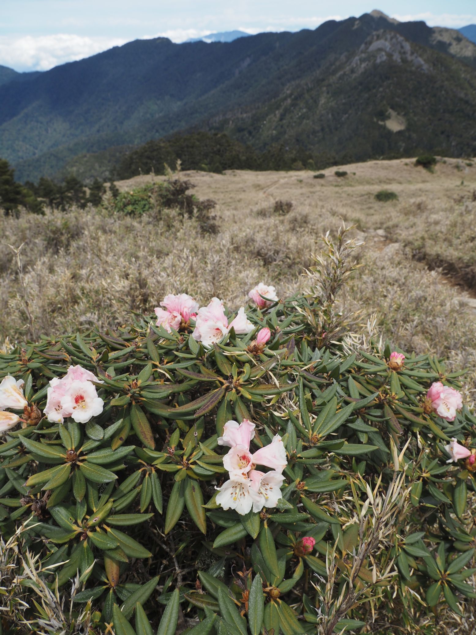
Kupo means a slope that makes you cry. It is in fact a last stretch of major uphill sections before the trail gets flat. It is just 100 meters in terms of altitude gap and much shorter than the section we have come up so far. It may be called so because hikers get already tired at its bottom and this exposed section of uphill gives them feeling of desperation. We spend about 25 minutes to complete its climb and reach its top at 13:13. This is 4.4K point so we have only 2.7 kilometers left to go. As we proceed, rhododendrons welcome us with a bunch of white and pink flowers. How nice to see so many flowers! There are some ups and downs to get to Mt. Xue-shan east peak (雪山東峰, elevation 3210 meters) where we reach at 13:50.
 |
| Inside of the lodge |
 |
| Front yard of the lodge and kitchen cabin |
The lodge has two rooms of bunkbeds. Our bed spaces are assigned to ones in the right room. When we arrive, there are still many blank bed spaces but by the time it gets dark, almost all spaces are occupied. This route is so popular and many hikers stay this lodge. So-called Xiezuo (協作), a kind of cater and porter combined, offers catering to those hikers who do not bring food themselves. They also rent a sleeping back, so you can climb M. Xue-shan only with light stuff of your own. Around 16:30 we get out onto a front yard beneath the lodge and have dinner that we cook ourselves. Catering service by the Xiezuo starts at 17:00 and many hikers come out to have their dinner. The lodge has no dinning hall.
 |
| Pintian-shan peak |
 |
| Thermometer of the lodge |
A thermometer attached to the lodge front porch shows 9 degrees in Celsius. We go to bed by 19:00 anticipating a good weather tomorrow. The distance of today was 7.1 kilometers with a total ascent of 1174 meters and descent 74 meters. We spent 6 hours and 10 minutes including breaks. The route physical index was 25.
=========================
Day 2: April 21 (Thu) 369 lodge - Mt. Xue-shan main peak - Cuichi cabin (翠池山屋)
 |
| Over the summit of Mt. Xue-shan main peak to Cuichi |
 |
| People are busy taking picture of sunrise |
Some hikers got up as early as 2:30 or so and went up to the summit of Mt. Xue-shan to see a sunrise. We do not need to haste like that, so get up after 4:00 and have a breakfast around 4;30. The kitchen room beneath the lodge is empty as the xiezuo served hikers breakfast much earlier. A little after 5:30 we see the sun rises over clouds. Soon after that we set off for our climb today.
 |
| Just about to depart |
 |
| Junction near the lodge |
The trail goes up on the large empty meadow in a zigzag manner. It soon diverges a trail right which leads up to the Holy Ridge beneath Mt. Kailantekun-shan. I came down by this trail on my last visit. The trail gains height every time it turns direction of zigzag. The lodge looks smaller and the view gets wider as we keep climbing. We reach the end of this section of meadow climb at 6:05 and enter the so-called black forest, which is in fact a large primordial forest of single white fir species.
 |
| Going up in a zigzag way |
 |
| Into the "black forest" |
 |
| a wild serow |
Soon after we pass by 8.1K maker at 6:30, we hear rocks falling. When we take a look for the spot we find a Formosan serow just up on the left slope. This is my first time to see the animal so close. As a matter of fact I encountered the animals near this place before but they were far in the distance. In addition to this serow there are two more down on the right slope too. They are probably crossing the trail when we come in. So one of them waits for us to pass but rocks under his foot fall and makes us to notice him.
 |
| "Shipu" |
 |
| Meeting early-bird hikers coming down |
At 6:42 we pass a large debris of rocks small and big, which is called rock fall (Shipu, 石瀑). This location happens to be 8.6K. The trail then gets suddenly very steep and pass a water source where water is seeping out of the rock seam. A hose and a bucket is set to collect water by it. The steep slope lasts for a while and the trail gets moderate. We walk up to where wind is rather weak an have a rest at 7:12.
 |
| Into a forest of Juniper trees |
In twenty minutes we come out of the pure fir forest and go into a forest where junipers (圓柏) are more dominant, which proves that we are getting closer to the timber line. The altitude is more than 3,500 meters above sea level. At 7:55 we come out of the forest and enter a corner of a large cirque (圈谷) under the summit. This cirque is known for its large size. We reach the flat space of it where some instruments are placed and have a rest. This is 9.8K point, one more kilometer to the summit.
 |
| Reaching the bottom of cirque |
 |
| Climbing near the junction (behind) |
There are two paths from this point. One on the left is to get onto the ridge and then to the summit. One on the right is to cross the cirque and up to the lowest point between the main peak and Mt. Beilengjiao (北稜角). We take the left and go up. Clouds still hang around and frequently conceal the upper part of the mountain ridge and peaks. The nearer we get to the ridge, the stronger wind blows. At 10.5K marker we get onto the ridge. There still remain patches of snow, but not much. When I climbed
Mt. Xue-shan in April several years ago, there were more remaining snow, although it is said that they had more snowfall than usual this winter.
 |
| Clouds clear and the whole cirque is visible |
 |
| A match of remaining snow at 10.5K |
 |
| At the summit of the main peak |
Fast moving clouds sometime show the whole cirque and beyond and hide it next instance. We climb the final stretch of a few hundred meters and get to the summit (elev. 3886m) at 9:43, which is at 10.9 kilometers from the trail head. This is my forth visit to it. We stay nearly a half hour, but a wide view does not come around. We leave the summit at 10:10 and soon see a another distance marker of 0K for the Holy Ridge route.
 |
| A new distance marker for the Holy Ridger route |
 |
| Down to a junction in front of Mt. Beilengjiao |
Approximately 10 minutes walk on a moderate downhill from the summit brings us to the lowest point before Mt. Beilengjiao. This is where another path from the cirque bottom leads to. Wind is blowing very strongly through. We take left and go down for Cuichi where we will stay tonight. It should be quite possible to keep on going on the Holy Ridge and get to Xuebei cabin (雪北山屋) before dark. By doing so, you could shorten one day of the trek. But this is not what we planed.
 |
| A long way down on pebbles |
 |
| Into bushes of low junipers |
The trail goes pretty steeply down on gravels. You have to watch you feet not to slide away. The small gravel turn to big rocks as we come down for 15 minutes. It is not easy to walk on rocks either. We get from the barren stone field into bushes and have a short break at 10:52. We are out of clouds at this altitude and enjoy the moment under the sun. We have only a kilometer to go.
 |
| Having a break |
 |
| Going along a traversing trail |
 |
| Primordial Juniper forests |
The gradually descending trail travers the mountain side and gets into a forest of large juniper trees. This is one of the large primordial juniper alpine forests of Taiwan. As we go further, trees like giant Japanese bonsai (盆栽) show up one after another. The final downhill leads us to Cuichi where we reach at 11:41. Clear water of Cuichi pond reflects sky, which can be seen through juniper trunks. Our little Cuichi cabin stands at the edge of this fairy-tale piece of land.
On my last visit here a few years ago, we just passed and I wished to have a chance to stay overnight.
 |
| Looking up the two peaks and the junction where we came down |
 |
| A view at sunset |
The activity today was pretty short, only 5.6 kilometers and 6 shours. The total ascent was 742 meters and descent 329m. The route physical index is 20.
=========================
Day 3: April 22 (Fri) Cuichi cabin - Mt. Xue-shan north peak - Sumida cabin (素密達山屋)
 |
| Return to the Holy Ridge and trace it to Sumida cabin |
 |
| Ready for the long trek |
We get up around 4:00. The dark sky yields starts when I get out of the cabin and look up. We set off at 5:30. It will be a long day today. We are going to climb back to the junction between Mt. Xue-shan main peak and Mt. Beilengjao. It is still cold but I feel hot after climbing for 15 minutes or so. We make a short break at 6:15. Across the valley
Mt. Le-shan (樂山) stands with a radar facility on its top and
M. Jiali-shan (加里山) on the left behind Mt. Le-shan. The Holy Ridge is still very high up there and a single line on the mountain side of gray barren rocks leads to the summit., which we will take on soon.
 |
| Still a long way to go |
 |
| Mt. Le-shan in the center and Mt.Jiali-shan on its left |
 |
| Struggling upwards with familiar peaks behind |
The gap between the Cuichi and the ridge is approximately 300 meters in altitude. We have come up a half of it. As we climb further, the grade gets steeper and wind gets stronger. The higher we get, the wider the view spreads. Now we can see the entire range of
Xue-shan west ridge (雪山西稜),
south idge (南稜) and the range of
Mt. Baiguda-shan (白姑大山) in the background. At 6:52 we returned to the Holy Ridge again and the view of other side comes in our sight. The large cirque leis beneath our feet and
Mt. Nanhuda-shan (南湖大山) and Mt. Zhongyangjian-shan (中央尖山) stand over the ridge of Mt. Xue-shan main peak down to the east peak.
 |
| Going on the land of rocks and low shrub |
 |
| At the summit of Kailantekun-shan |
We follow the trail and pass a couple of humps, which is without any difficult places. Passing by a 1.6K marker at 9:19 we soon arrive at Mt. Kailantekun-shan (凱蘭特崑山, elev. 3731m). The section of the ridge that we have just come along is almost as high as Mt. Fuji of Japan. We meet a large group of hikers heading in the opposite direction. We keep on the ridge trail and get to a junction at 9:47. The trail on our right goes down to the 369 lodge. We soon pass a 1.9K marker and reach the summit of Mt. Kailantekun-shan north peak (elev. 3705m) where we have a long rest of twenty minutes. Mt. Xue-shan north peak is now much closer while Mt. Beilengjiao is already far and high.
 |
| Going up this rugged climb |
 |
| Going down is not easy eiher |
At 17::00 we see a 5K marker. There are only three hundred meters to go. The trail still does not allow us to go easily. More tiresome ups and downs are thrown at us. At 17:20 another fairy-tale cabin shows up in a forest of white fir at last. Water of the cabin is supplied by the large tanks behind the cabin, which store rainwater. I look for water in the first tank and find empty. The second tank is OK which makes me relaxed. There is a flowing stream down in the valley, but you have to go two hundred meters down to fetch water, which would be very demanding after our long walk. This cabin has a upper floor too. There is no other occupants today. After dinner everybody goes to bed before 20:00.
 |
| Sumida cabin of a fairly tale land |
Although we have long breaks on the way, it yet took us 11 hours and 50 minutes to complete 7.6 kilometers. The total ascent was 590 meters while descent 616 meters. The route physical index is 30.
=========================
Day 4: April 23 (Sat) Sumida cabin - Mt. Pintian-shan - Xinda cabin (新達山屋)
 |
| The shortest but most risky section |
 |
| In rain ware and ready for the challenge |
I usually refer to two weather forecast applications. One is Taiwan's own meteorology forecast and other is Windy. While we were able to access mobile network before noon yesterday, I checked them. The Taiwan's forecast showed that a cold front would come and there would be a chance of rain. The other was positive and no chance of rain. After I woke up, I went out to find there were no stars. By the time we were ready at 5:15, we found the front deck of the cabin was wet. Between the two conflicting forecasts, the former proved right, which means big worry because we have to go through the most risky section of our trek: Sumida cliff and Pintian cliff.
 |
| Heading for Sumida cliff in a forest of white fir trees |
 |
| A shiny new ladder |
Everybody puts rain ware and at 5:30 we leave the cabin behind with an uneasy anticipation. It is good that mist is not thick. We still can see far distance though clouds hang vey low. We go down and pass a 6.6K marker, then come to the bottom of Sumida cliff at 5:45. A new shiny ladder is fixed on the vertical rock wall besides a warning plate. This ladder has been attached since my last visit. There was no such equipment in the past. There was an argument of whether or not to fix such a thing in a natural environment. I believe that this is a good measure to prevent accidents which deprived many lives. The ladder is much more dependable than a bunch of ropes.
 |
| Coming up one by one |
 |
| Further going up to Mt. Sumida-shan |
 |
| Summit of Sumida-shan |
We go up the ladder one by one and traverse to the next rock wall climb. This has no ladder here but stainless anchors and new ropes have been added. This would help safe passage. We all pass this cliff by 6:15. It is lucky no rain drops during our climb. We keep on our way up to Mt. Sumida (素密達山, elev. 3517m) where we reach at 6:22. This section between Mt. Sumida-shan and Mt. Buxiulan-shan (布秀蘭山) is a very rugged ridge with very vertical cliff on both sides. Mt. Pintian-shan is much closer now, standing like a fortress of rock kingdom.
 |
| The second cliff |
 |
| Lifting backpacks up (a member's picture) |
 |
| The last cliff |
Encouraged by the recovering weather we keep on our way up to the final cliff, which proves the easiest of the three: the shortest with a lenient angle and ample footholds. It has gotten new stainless steel anchors embed into the rock wall. We all pass this cliff and advance a final short climb to the summit (elev. 3524m). We reach the summit in full of sunshine at 11:37. I am really happy that we have successfully made through the most difficult section. There was a fatal accident at the second cliff only in December last year.
 |
| Reaching the summit |
All we have to go from now is just down to Xinda cabin, which is just 1.5 kilometers away. We have plenty of time to spend on this summit. My second visit to the summit is greatly rewarded. When
I first stepped on this summit six years ago, the ridge extending to the Holy Ridge looked so rugged and fearsome that I never though that I would come from that direction. This peak is popular so many hikers come and go while we stay there for one hour.
 |
| Pleasant walk on the meadow |
 |
| Xinda cabin |
The last leg of today's hike is pretty easy, only several hundred meters down in length. The trail gets into a forest with a steep downhill and gets out to reach the cabin at 14:47. This cabin, like the one yesterday, has two floors. Our bed spaces are assigned on the second level. After settling down, we go out and have a dinner. This route, so called Wuling Sixiu (武陵四秀), is quite popular. In addition to that today is Saturday, hikers are all around and a few tents are up besides the cabin. The weather forecast says that it will be fine tomorrow too. Thinking about the last four days, I go to bed sometime after 19:00.
The distance was just 3.7 kilometers while we spent almost 9 hours though we have long break at the summit of Mt. Pintian-shan. The total ascent was 220m and decent 541 meters. The route physical index is calculated 18.
=========================
Day 5: April 24 (Sun) Xinda cabin - Mt. Chiyou-san - Wuling villa (武陵山莊)
 |
| Down to Wuling Villa and visit to Mt. Chiyou-shan en route |
 |
| The sun rises besides Chiyou-shan |
Today is the final and the most carefree day: We just go down and have a little climb to the summit of Mt. Chiyou-shan en route. So we get up late and have a late breakfast. Almost all other hikers have long gone for their own way. One member leaves alone himself because he needs to get his car and back to Taizhong early. The rest seven of us leave the cabin behind at 6:30. With almost all food having been consumed, the backpack is light just like our heart. The sun is already high. We soon pass Xinda pond (新達池) in a flood of sunlight and a junction to Mt. Dabaojian-shan.
 |
| Famous Chiyou tree |
 |
| Passing the cliff of the famous tree |
We pass by the famous tree and get to a junction to Mt. Chiyou-shan at 7:42. We dump backpacks and climb to the summit without anything. The summit is just less than 100 meters up there and the trip to it won't take long. The trail is going up very steeply in the forest for a while and gets out to a meadow. We reach the summit (elev. 3303m) at 8:07. It took only 13 minutes to get here. This is a good vantage point. You can have an all around view. Mt. Dabajian-shan and adjacent peaks stand side by side across a deep valley. On the east, the central mountain range (中央山脈) rises like a long high wall. Mt. Pintian-shan stands on the west. Even Wuling Farm in the valley can be clearly seen. While we enjoy the summit, another group of people come up.
 |
| Climbing light to Mt.Chiyou-shan |
 |
| Almost the summit |
 |
| At the summit of Chiyou-shan |
 |
| Impressive Dabao-jian and its sister peaks |
 |
| Wuling Farm down in the valley |
At 8:26 we leave the summit and return the same trail back to the junction where we reach at 8:35. We put backpacks on and continue our way down. The trail goes flat and pass a large rock debris section (rock fall). This is where another trail to the summit of Mt. Chiyou-shan diverges. We reach a junction of Sancha campground (三叉營地) at 9:00. The direction sign says 3.5K to the trail head. The other trail leads to Mt. Tao-shan at 2.3K away. We take right and soon pass the campground, which looks good for three tents or so.
 |
| Going down through a red pin forest |
 |
| At the trail head |
 |
| Keep going down to Wuling Villa |
The last zigzag downhill ends and at 11:12 we finally come down to the trail head by the walkway to Taoshan Waterfall. Many visitors to the fall pass by us while we have a break by the trail head. Most of them are tourists including children. Basically we have come back to a civilized world. We walk down for another 3.6 kilometers of the walkway. At a half way down, a single Swinhoe's pheasant is leisurely walking alongside the walkway. This is a rare occasion to be such close to the bird. We further go down and pass over a new suspension bridge of Wulengqiao (武陵橋) to reach Wuling Villa at 12:22. This is the end of our five-day trek!
We walked approximately 9 kilometers with a total ascent of 313 meters and descent 1573 meters for 6 hours. The route physical index is 18.
 |
| New Wuling suspension bridge |
-----------------------------------------
In short, this was a wonderful and memorable trek. It was good that my concern for safe passage of the two major cliffs turned out be just a worry and no more. I was glad to hear that every participant enjoyed the trek. I myself had a great time enjoying spectacular views and thrill of passing dangerous sections.
 |
| 阿里山龍膽 |
As the hiker population increases, so called "100 peak" hunting gets more popular., I believe that this trend is basically good because it draws more attention to alpine Taiwan and expands general recognition of its beauty. The peaks of this trek are all my second visit or more, not adding to my 100 peak count. Visiting the same peak more than once gives you a different perspective that you appreciate in a different way. I find it a lot of fun too.
For five days we trekked 33 kilometers with the total ascent of 3041 meters and descent 3133 meters for the total of 48 hours including breaks. The route physical index amounts to 111.
Lastly one advice: If you plan to trek this route, I would strongly recommend to book on line your cabins at 7:00 a.m. precisely two months prior to your departure day. The number of bed space at each cabin is limited, especially Cuichi cabin. They are filled up very quickly, particularly for weekends and national holidays.