 |
| Mt. Zhuzihu viewed from the trail, Mt. Datun stands left in thick fog |
陽明山周辺の山腹斜面は、早い時期から開拓されてきた。そのため、100年を超える灌漑水路がたくさんある。山の沢の途中から、山腹を横切り目的の田畑を灌漑するように造られている。內雙溪の
平頂古圳はとても有名で筆者も何回か訪れている。それ以外にも、それほど知られていないが、水路沿いに歩ける場所がたくさんある。今回歩いた十八份圳と十八挖圳は、それぞれ1821~1850年に1851~1861年開削されたということだ。当時はほとんどが手作業、部分的に水牛などを使ったとしても、大変な労力を投じたのだと思う。
 |
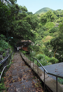
| 十八份圳 Shibafen canal |
今回の登山は、もともと前日23日に予定していた坪林の山行が悪天候のために中止となり、24日が梅雨の中休みなったことで計画実行した山行である。そんなこともあり、天気が比較的よい場所を選び、比較的楽な歩きとした。竹子湖山のある竹子湖は、実は一週間前に訪れている。それもやはり代行案であった。竹子湖山は標高700m、そこからは基本ずっと下りで、天母に降りた。途中には温泉源泉地である地熱口を通過した。筆者にとって、初めて見る陽明山の一面に触れた。陽明山は、外国人も多く登る山域だが、ほとんどは公園内の官製道だけを歩いているようだ。前回に引き続き、もっと陽明山の非官製路を知ってもらうため、英語で記述します。
===============================
So-called Yanmingshan (陽明山) does not represent a single mountain peak, although it includes the word shan (山) meaning mountain. It denotes a whole range of mountains and hills north of the Taipei basin. The term is also used a a National Park located there. The original name was Caoshan (草山), meaning mountains covered with grasses and low shrubs. It was changed to the present Yanmingshan after the KMT government came in.
 |
| Start from east side Yanmingshan bus terminus to Tianmu park |
 |
| Hiking elevation profile |
The hills of the area had been cultivated since early time by immigrants from the Mainland China a few centuries ago. Moderate slopes of the mountain sides were cleared and transformed to farm lands. They needed water to irrigate the crops and opened canals with great efforts. The canals have been maintained and upgraded over the time. Most of them are still in use and some of them have been added sidewalks by the local government for hiking, like Pingding Canal trail (平頂古圳步道), which is well know and traveled by hikers. The canals which we hiked this time are Shibafen canal (十八份圳) and Shibawa canal (十八挖圳) . A nice sidewalk was added to the latter one and maintained by the Taipei municipal government. They are pretty old, Shibafen canal was built in 1821~1850 and Shibawa canal in 1851~1861. They are still supplying plenty water to the crop fields today.
 |
| Yangmingshan bus terminus and trail sign |
Originally I had a hiking plan on the day before (May 23). Who knows May rain season came in and we had a heavy rain on the day. The hiking was thus postponed. Subsequently I made up a plan of easy hiking to compensate the original activity. Seven friends showed up at 9:00 Yanmingshan bus terminus, where we start this hike. The sky is still not as clear as the weather forecast says and the trail surface is still wet. Our first destination is Mt. Zhuzihu (竹子湖山) which is a small peak beneath the massive Mt. Qixing (七星山).
 |
| The junction of the pedestrian trail right to Mt. Qixing (七星山) |
 |
| A long way up |
We walk along the pedestrian trail (人車分道), which goes along the Yangjing highway (陽金公路) very next to it at some points and quite far from it at others. The pedestrian trails as a system circle around the side slope of Mt. Qixing and you can follow them to return to the Yanmingshan bus terminus. The stone paved trail follows the right side of the motor road after passing through the entrance tunnel and climbing up three story-high steps. At 9:25 we come to the Yanmingshan visitor center and make a short brake.
 |
| Down to Yangjin Highway and cross it |
 |
| Zhuzihu police station |
We pass through the garden and come to the boy scout camping field. There is a stone monument just by the trail. It is a memorial stone of his highness late Showa emperor of Japan visiting Taiwan in 1923 as a crown prince and his marriage in 1924, and also commemorating the long-term reforestation on the mountains of the time. A new explanatory board now stands by it. Passing by the stone we come to a junction where a trail to Mt. Qixing branches out to your right and upwards.
 |
| A junction ahead beyond Hutian bridge |
 |
| Trail to Mt. Zhuzihu through ceder woods |
The pedestrian trail ascends by a long step way and levels off. Following the trail for about 15 minutes and it comes down to the Yangjing highway. We cross the motor road. The trail now goes on the left side beneath the motor road and we come to Zhuzihu police station at 10:04. This is a gateway to Zhuzuhu area. Now is the season of hydrangea flowers and many visitors are walking to the flower fields. It drizzles and I take out an umbrella. While we fallow the trail, the misty rain stops. We come to a junction by Hutian bridge (湖田橋) and take right to go up a little.
 |
| At the summit of Mt. Zhuzihu (竹子湖山) |
 |
| Junction left to Houkan Road |
We soon see a trail head leading to the summit of Mt. Zhuzihu, where a car is parked and obstructs passage. The trail is pretty clear and goes among Japanese cider forest. At 10:25 we easily arrive at the summit where a small triangulation stone sticks out and trees surround. At the elevation of 701 meters this is the highest point of our hike today. We return on the same trail down to the paved road. We take right to the junction where we were just passing a while ago on the way to Mt. Zhuzihu and then take right again. In five minutes we come to another junction where Houkan road (猴崁產道) branches out to left.
 |
| Going down to Houkan canal |
 |
| Very little water flows in Houkan canal |
We go down along Houkan road, passing a small stone house with an address plate of 竹子湖路33之10, and come to a junction. We turn right to a dirt trail and soon see a small trail branching between trees on our left. This trail leads to
Houkan canal trail (猴崁古圳), which we visited just a week ago. It goes gradually down the hillside. We unexpectedly run into a group of three friend hikers, who we just parted at the bus terminus. They did not mention any particular route that they would take, so this is a kind of surprise to us.
 |
| Go down along grass-covered trail |
 |
| At junction under a old maple tree |
At 10:50 we get down on the canal. Compared with the last visit, the water level is pretty low. As we go down along the canal, the stream dries up. I wonder whether the water is diverted at some point upstream. In a matter of five minutes we come to a junction and take right. The trail is rather narrow and covered with grasses at some locations. At 11:04 a four-way junction appears by a big maple tree. The tag on a tree shows 100-year old maple tree (百年楓香巨木). I am not sure whether it is 100 years old, but it is much taller and thicker than adjacent trees. We have a short rest under it.
 |
| Very steep descent |
 |
| Tudigong shrine by the river (on right) |
The trail goes down at very steep angle. This section is not so in good shape and you have to pay close attention to your foot. Stone blocks are placed at some places, which seem to be a part of stone pavement or steps of the past. This section of trail must have been long neglected and left to be this poor state. The weather has turned out sunny and the sun ray seeps through woods, marking bright spots on the trail surface. We come down to the bottom of the trail by Huangxi river (磺溪), where a stone shrine stands on a concrete platform. The shrine is covered with a roof above it. Obviously local people come and worship here. This indicates that the trail we have just come down has remains of stone pavement because it must have been an important passage for the local people in the past.
 |
| Crossing the strong current of Huangxi river |
 |
| Huangxi river, an university building far beyond |
We cross the stream. The current is pretty strong as rainfall lasted in the past few days. We select a rather shallow part and pass the current. From the opposite side starts a canal. The water is inducted to the canal at this point. This is a head of Shibafen canal. We walk along the canal, which has a concrete passage on its left side. It is nice and easy to walk. In a few minutes the valley widens and we see a road and bridge below on our left. We leave the canal, which still goes on further, and go down to Dongsheng road (東昇路).
 |
| A view from the canal, overlooking a bridge and Dongsheng road, Mt. Shamao in the distance |
 |
| Shibawan canal running just by the rice paddy |
We take Dongsheng road to left and walk towards the head of another canal, Shibawan canal. The map on my hand does not show exactly where the trail by the canal Begins. We pass the bridge but still find no entrance and get back. Then I find an opening just after passing the bridge. It goes down to the river and beyond the stream the canal starts. The current now is yet more stronger. After studying, I give up to cross it, decide to walk along Dongsheng road and see a point of approaching the canal.
 |
| A farmer working by the canal |
 |
| Water rushes down |
Walking back to the point where we came dawn from Shibafen cana, there is a narrow path going down by the paddy fields on the left side of Dongsheng Road. We go down to the canal by narrow paths. Finally we get down on the canal by a rice paddy where young plants are just growing. The first part of the canal is pretty easy to follow as it is very flat. On our far left stands Mr. Shamaoshan (紗帽山) and we can make out buildings of the city far beyond the valley. If a few minutes it comes to a point of very steep angle downwards. Water rushes down. We carefully walk down on the steep canal wall top, which is wet and looks slippery. At 12:20 we finally come down to a platform of resting area, where the official Guaijun trail ( 拐圳步道) starts. We have a long rest for lunch on the platform.
 |
| Rest platform by the canal |
 |
| Guaijun trail (拐圳步道) |
The sky is now free of cloud and nice blue. Members have brought several cans of beer and we share and enjoy it. It is very nice to have cold beer on mountains. We resume our hike after 45-minute break. We go down on staircase and continue on a trail along the canal. The trail is in good shape. Some sections have concrete-made handrails. On the resting platforms on its way there are benches and boards explaining history and ecology of the place. In fifteen minutes we come to Leshan Pingtai (樂山平台) platform. A bossy monkey is sitting on the handrail. He does not afraid of men at all and watches us, as if he commands food to feed him.
 |
| A macaque at Lashan platform |
 |
| City view from the trail |
 |
| Mr. Qixing (high and far on the left) and Mt. Shamao are very clear against the blue sky |
 |
| Climb down to the bottom of valley |
We keep on the canal trail and another trail is coming from right to join. Passing an open area, we take left on a narrow trail down to Quanyuan Road (泉源路). On the side of Quanyuan Road we find a bus stop. You can take a bus down from there, but all members want to walk all the way down to Tianmu (天母). We go left a little and get into a stone-step pathway down to the bottom of the valley. Passing Huangxi river over a bridge, we go up again to a traversing trail. The trail soon goes down and passes over a sub stream of the Huangxi river. We pass another bridge where the sub stream joins the Huangxi main river.
 |
| Climbing back from the valley bottom |
 |
| Going by Huangxi river in the valley |
 |
| Guangong (關公) |
The valley wall of either sides are high and steep, giving an impression of a deep valley. We soon pass by Miaotiangong temple (妙天宮). There are many deity statutes alongside the trail like Jigong (濟公), Buddha and Guangong (關公). Going over Zhulin bridge (竹林橋) to the right side of the river, we come to a Tudigong (土地公) temple at 13:57. We have a rest in front of the temple.
 |
| Tudigong (土地公) |
 |
| A family strolls down by the shrine |
This place is more for tourists than hikers, and we run across families including small kids. We soon come to Direkou (地熱口) open valley. This is where hot spring water is collected to supply hot spring bathes down the valley. You smell sulfur as you go. At the end of trail we go up to Xingyi road (行義路) above. Xingyi road is a busy with traffic going up and down.
 |
| Direkou hot spring |
 |
| Making a turn into Xingxi Road Lane 192 |
We see a couple of hot spring houses being out of business as we go down the road. This is my first time to walk down the road, though I traveled by bus or car many times in the past and did not notice such establishments. We get into Xingyi Road Lane 192 and leave busy traffic behind. This is a residential area and we pass by many houses and buildings old and new, and get down to a road at the bottom along the river.
 |
| Going down on the residential street by Huangxi on right |
 |
| Getting out of Jaiguilin mountain villa area |
As soon as getting out of Jiguilin mountain villa (甲桂林山莊) and pass a bridge over Huangxi river, we enter Tianmu park (天母公園) at 14:50. This is our final destination. We have a nice and long rest with the final two cans of beer, which is still cold, under one of many pavilions in the park and then walk up to Tianmu bus stop on Zhongshan north road section 7(中山北路七段) to take a bus home.
 |
| Heading for Tianmu bus stop through the park |
We talked approximately 14 km, taking 7 hours including rest. The total ascent 470 meters and decent 930 meters. This route is definitely downhill and easy in terms of physical requirement. However some sections of the route are not necessarily in good condition and you have to cross a stream or two. You need some experiences of stream crossing and finding routes. This can give you another glimpse of what Yangmingshan can offer, though.


