 |
| 元の橋の上に新しい吊橋,A new suspension bridge over an old one |
新北市烏來區は、山岳地帯である。稜線は、桃園市や宜蘭縣との県境を構成する。標高は2000mを少し超える峰もあるが、さらに南の3000m超のような高山はない。しかし、平地からは遠く、山は高く谷は深い。そうした山々は、その昔はタイヤル(泰雅)族のテリトリーであった。台北からそう遠くはないが、ここはほかの台北周辺低山とは趣を異にする。今回歩いた場所は、そうしたなかで台北に近い場所に位置する。新店から新烏路を進み、烏來の街に着く前に登山口へと続く。
今回の登山対象は、今までに訪れている場所だ。高腰山と拔刀爾山は10年前に初めて訪れた。この二座の北側の谷をいく紅河谷古道も、何回か歩いた。したがってこの山行のルートの大部分は、再訪ということだ。違うのは、高腰山へのアプローチと紅河谷古道の峠へと続く尾根道の一部だけである。山行の目的の一つに、その後控えている数日の高山縦走のための、体調確認という意味もある。歳を重ねるにつれ、体力が落ちていく。そうした中で、事前に自分の現在体力を確認することである。
------------------------------------
 |
| Location of Wulai relative to its adjacent units |
The current Wulai district (烏來區) of New Taipei City (新北市) municipality lies deep in mountains and valleys. Its population mainly stays in villages and towns alongside Nanshi-xi river (南勢溪). Its border with neighboring administrative units goes all on the mountain ridges. This was a territory of Atayal indigenous people (泰雅族). The Han people (漢人) did not dear to enter until the late 19th century because they might well have been caught and beheaded if they intruded the territory. It still is predominantly a place of the indigenous tribes as you witness their cultural objects upon entering the area. The mountains of Wulia is different in terms of ethnicity from other low altitude mountains surrounding the Taipei basin.
 |
| Map of our hike track record |
The destination of our this hike is located rather at the front of this vast region of mountains and valleys. Just before reaching the town of Wulai, Jiajiuliao-xi river (加九寮溪) splits right from the main stream of Nanshi-xi river. A range of mountains rises between Jiajiuliao-xi river and Nanshi-xi river, which includes Mt. Meilu-shan (美鹿山), Mt. Gaoyao-shan (高腰山) and Mt. Badaoer-shan (拔刀爾山), and it further goes up to connect the main ridge of Chatian-shan mountain range (插天山山脈). There is a trail called Honghege old trail (紅河谷古道) going along Jiajiuliao-xi river. The ridge including Mt. Gaoyao-shan and Mt. Badaoer-shan and the old trail are where we hiked on this occasion.
The Honghegu trail is said to have been a passageway between Atayal tribes living on the both sides of the Chatian-shan mountain range for inter-tribal marriage and family gathering. It must have been used for hunting as well. It links present-day Jijiuliao or Chenggong (成功) of the Wulai district and Xiongkong (熊空) of Snaxia district (三峽區) of New Taipei City. The trail was devastatingly damaged a few years ago by Typhoon and then again by heavy rain last year. It has been repaired for passage for each time. In addition to that, the section of Wulai side from its head to 3.5-kilometer point where a an abandoned worksite shed stands has recently been upgraded to be a nice hiking route by the authority.
-----------------------------------
 |
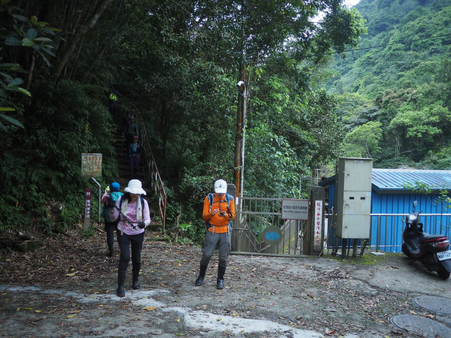
| Henghegu trail head |
 |
| A new bridge replaces a log one |
Today's hike is going to be a long one. Five of us ride a sharing car from Taipei to the head of Honghegu trail where we reach at 6:08. Other three members are already there who have come by their car and motorcycle. The sky is gray but it luckily is not raining. We set off at 6:20. The trail starts with concrete stairs. We soon find that the trail has been upgraded. Where a log bridge was placed now lies a a wide wooden bridge for easier passage. At 6:30 we come to the bottom of a climbing section and find a brand new wooden staircase. As we go up a milepost of 0.5K shows up. How nice they are!
 |
| New stairs and a distance marker |
 |
| Graveled track and water gutter |
 |
| A new suspension bridge and a discarded old log bridge beneath |
 |
| Identical location 3 years ago |
As the trail gets flat again we find gravels have been placed on the track surface and a small water gutter, all of which did not exist on our last visit a couple of years ago. At 6:41 we pass by 1K marker and soon pass a resting area where new wooden benches have been placed. A new small suspension bridge hangs over a creak which replaced a crude log bridge of the past. It looks that they invested a sizable budge to upgrade the trail. At 6:57 we come to a junction where a trail to Mt. Gaoyao-shan splits (elevation 220m).
 |
| Steep climb to Mt. Gaoyao-shan |
 |
| Going around the big rock |
Much less hikers travel this trail up to Mt. Gaoyao-shan. The track is obviously narrower and less clear. The gap in height to the summit of Mt. Gaoyao-shan (elev. 980m) is as much as 750 meters but the distance is only two kilometers, which calculates to an average of 37% incline. The trail is naturally very steep with few flat sections. The trail goes among various kinds of broad leaf trees. It sometimes passes over a stretch of bare rocks, some of which have ropes affixed. On a such wet day like today, this kind of safety measure is pretty appreciated. After an hour of unbroken ascent we see a rather flatter stretch where we have a break.
 |
| Exposed rocks and a rope |
 |
| Climbing among cedar trees |
 |
| A final ascent to the summit |
A short moderate ascent where cedar trees glow is succeeded by another steep slope among broad leaf trees. In another half hour we find mist is gathering. The altitude is already 860 meters or so. We climb two long and steep slopes where ropes are fixed and come to the summit at 9:04. It took us two hours to get to the summit. Only one side of the summit is without surrounding trees and gives out a sight towards
Mt. Datong-shan (大桶山) under thick hanging clouds. This is
my second visit to the summit of Mt. Gaoyao-shan. The last one took place ten years ago. I came from the Mt. Badaoer-shan and went back to the main ridge, not from the bottom like this time.
 |
| At the summit of Gaoyao-shan |
 |
| A view towards Mt. Datong-shan |
 |
| Heading for Badaoer-shan |
The trail gets clearer and wider because more hikers visit the peak from the main ridge trail. The trail first goes down for a while and climbs back to a junction with a trail running on the main ridge, where we reach at 9:29. We take right and follow it to meet another trail which leads to Mt. Badaoer-shan. The mist is pretty thick now but no rain. We pass a narrow passage between rock walls. Water is running under our feet. We all have rain boots on today, which is really suitable for such trails. At 9;46 we come to a flat open space where you may place a couple of tents and have a rest.
 |
| Narrow passage between rock walls |
 |
| Flat open space for rest |
 |
| At the summit of Badaoer-shan |
Another 10 minutes of trace on the ridge trail brings us to a junction where a left trail leads to the summit of Mt. Badaoer-shan (elev. 1117m). We reach there at 10:20. Dense mist prevents any view from the summit where you can have a good vista on a fine day. We have so far covered about one third of today's hike. The two peaks we have just visited are easily reached if you start from Baoqinggong temple (保慶宮). The starting point is already very high and the trails are good. The trail that we will follow from here is not for beginners, though.
 |
| A warning notice: is it necessary? |
 |
| A narrow ridge with exposed rocks |
 |
| A freshly dug hole |
Upon getting back to the junction we take a trail left. A notice is attached to thin strings between trees saying that you have to think twice before stepping in. The trail looks undependable compared with the one that we have since come along. As a matter of fact, I passed though this trail several years ago from
Mt. Zhulu-shan (逐鹿山). So we will go in the reversed direction this time. The trail goes steeply down and follows on a narrow ridge which shows slippery bare rocks at some points. On our way we encounter a few freshly dug holes. They must have been dug by wild boars. We finally reach the bottom at 11:15. Wind is blowing through. We further follow the trail on the ridge which now turns very wide for ten minutes or so and get to a place with little wind where we have a lunch break.
 |
| Keep going down |
 |
| Place for lunch |
 |
| Follow the markers |
We resume our hike a little after noon. The trail goes over several small ups and downs to come to a junction at 12:26. The map shows that there is a trail traversing on the north mountain side to the main ridge. We look for the trail that should leave for right, but there is only a scant track. It soon disappears as we follow it. With help of GPS we keep on going for a while even in thick vegetation. There is no markers at all. At the point where we have advanced about 100 meters or so, I decide not to follow this trail and get back to the original trail. Obviously it has long been disused and the track is not dependable. It would take much longer time to follow it like this than the other trail, which is much longer in distance though because it is as if going two sides of a triable. We are back at the junction by 12:55.
 |
| The track disappears in thick vegetaion |
 |
| Back at the junction |
 |
| Reaching the main ridge junction |
The other trail goes steeply from the junction up towards the main ridge and meets the junction up there at 13:14. I came down from Mt. Zhulu-shan to this point and headed for Mt. Badaoer-shan on my last visit. We take right at the junction. The trail on the main ridge goes up and passes a highest point. On our way down we find direction signs of year 2011 are attached on a tree trunk. There seems to be a track diverging on our right. Comparing with my GPS map, this could be another end of the traversing trail. There are very few hikers coming deep in this area to begin with, so it is no wonder the trail has been abandoned like this.
 |
| Old direction signs on the main ridge |
 |
| This may be another end of the abandoned trail |
 |
| Going down on the wide ridge |
The trail follows the wide main ridge, passing a junction at 13:37 where a trail diverges to go directly down to Xiongkong. A direction sigh says that this trail is closed due to severe land slides ahead. Our trail keeps descending and finally reachs the summit of Honghege trail (elev. 903m) at 14:06. We have a short break. It makes me feel relieved because we have only a way down along the much traveled trail, albite very long.
 |
| Junction of a closed trail |
 |
| Four-way junction: Summit of Honghegu trail |
 |
| Going down from the summit |
This is a four way junction. The ridge trail leads to
Mt. Jiajiuliao-shan (加九寮山). If you take left, the Honghegu trail leads you to Xiongkong. At 14:17 we take right and go down to where we started our hike this morning. The trail goes zigzig down among tall cedar trees. After a while it traverses along the left of hillside. We meet two young hikers coming up. They say that they will walk to Xiongkong. A half hour decent bring us to a junction. The direction signs are very old. The ascending trail on our left leads up to a (almost abandoned) trail running on the ridge of
Mt. Xiangtianhu-shan (向天湖山).
 |
| Junction to Xiangtianhu-shan |
 |
| Crossing the first stream |
 |
| Coming down to a stream again |
Another zigzag decent leads us to a small stream at the bottom. At 14:56 we cross a stream and goes on the right side of the stream. The incline gets more moderate now. The trail crosses the stream again where we have a break at 15:07 (elev. 530m) . I take off my boots and find a leech crawling on my pants. I take out salt from my back and sprinkle a pinch of it on the leach. It immediately shrinks and drops off my pants. Mountains of Wulai are indeed infested with leeches.
 |
| Salt covered leech |
 |
| Coming down to a stream bed |
We still have six kilometers to go. We go along the stream bed for a short while and get onto a left bank. It leads to another stream crossing. The trail goes all on the right bank from this point. The original trail met land slides at several locations and detours have been made to pass such places. It goes all way down to the stream bed twice to avoid debris and up again to the trail along the mountainside. As we keep going, the valley on our left gets deeper and deeper. At 16:09 we come across a fresh land slide where a scary path with a rope crosses. At 16:22 we pass over a log bridge and in a few minutes we reach an abandoned worksite shelter. It still stands Ok and can be used for an emergency. We have some rest at its front yard.
 |
| A fresh landslide |
 |
| Crossing a log bridge |
 |
| A worksite shelter |
 |
| Crossing a wide stream |
At 16:40 we set for our final leg of the hike. A trail soon crosses a rather wide sub-stream and goes up for high detour with stones and a new rope. This is what the authority recently built. We go further down to find a new suspension bridge hangs over the old wooden log bridge. A 3K marker post shows up soon after this new bridge . We pass over two more newly built steel-frame bridges and another suspension bridge. At 17:19 we pass by the trail head to Mt. Gaoyao-shan where we went up this morning.
 |
| 3K marker |
 |
| Crossing another new bridge |
 |
| Passing the rest spot with benches |
 |
| Back at the trail head before dark |
The rest of the trail is of course as good as this morning. We pass the rest area with benches at 17:25, go down a long stairway and a final flat stretch. We are back at the trail head at 17:50. While we change our clothes street lights turn on. By the time we drive down along Xiwu street (新烏路), the sky has turned dark.
------------------------
This hiking was a strenuous one for its length as well as vertical distance. My record shows 20 kilometers with a total ascent (and decent) of 1525 meters. We spent 11 hours and a half including breaks. The route physical index amounts to 43. This hike was in a way aimed to prove how well our physical condition fits for multiple day high mountain treks in coming months. Though the trails are all wet and slippery, it was lucky that it did not rain after all.
This entire route is just for experienced hikers while the front half up to Mt. Badaoer-shan is good for every hikers. If you are sure enough to have both physical fitness and navigational skills, it is worth a try for the whole route.


0 件のコメント:
コメントを投稿