 |
| 溪南尖山頂 Summit of Mt. Xinanjian |
2017年に一度訪れた
三峽の低山王公坑山から溪南尖山を縦走した。縦走といっても半日で終わるルートである。8年間の間に、以前の草深い山道からそこそこ歩かれるよい道になっていた。さらに、中華山岳協會が選定する台北天際線縱走路(台北スカイライン縦走ルート)の第九セクションとされているので、今後も定期的なメンテが期待できる。
今回の歩きは、前に歩いたルートを逆方向に歩いた。また今になってこの場所を選んだのは、夏が近くなり暑くなったので、早めに出発できまた何日ぐらいで歩き終われる、という条件で選んだ。もちろんここ以外にもそうした場所はあるが、なぜかここが気になった。ちょうどこの日は台湾の端午節三連休の中日にかかり、遠くに行くと混雑に巻き込まれるので、避ける目的もある。雨が三日ほど降った後の、好天気になったが、一方低山なのでやぶ蚊が多くそれは閉口した。すでに歩いているルートなので、英語で記述する。
------------------------
After more than a decade of visiting mountains around Taipei, it is inevitable to have exhausted in hiking mountains and routes there. Of course there are yet some routes that I have not been to, but when I look at my map and past experiences of 15 years, I can not find any area that I have never placed my foot on. I hiked this route 8 years ago. I chose this hiking route because it is close enough to start early in the morning and I can finish hiking in a half day. It is getting hot in these days so that I can avoid heat in the afternoon.
 |
| Hike counter-clockwise |
The route has since been designated as a part of Taipei Skyline Traversing route (台北天際線縱走路) of Taiwan Alpine Association (中華山岳協會), which means that more hikers come and hike this route. This would keep the trails alive and passable even if not being regularly maintained by volunteers. Low in the altitude and close to residential areas as they are, mountains in this area was not so popular. On our hike I found that the trail is better in shape than 8 years ago. Our route was the exactly same route in the reversed direction of my last visit.
 |
| At the summit of Xinanjian |
------------------------
 |
| A new MRT to Sanxia under construction |
Seven of us met at a bus stop of MRT Dingpu station (頂埔站) at 7:30. Originally I planed to start from the trail head near Zhengyi Diaoqiao bus stop (正義吊橋站), but its bus service is not frequent so changed to another starting point Datonglu street (大同路) bus stop, which happened to be the ending point of my hike 8 years ago. So we would go for the same route in a reversed way. Soon came #709 bus which calls at Datonglu stop . On my bus ride, I found that the new MRT elevated line to Sanxia (三峽) is very much completed and goes above the road. We arrived at Datonglu a little before 8:00.
 |
| Going along Datonglu Lane 87 |
 |
| Irrigation pond |
The lane 87 of Datonglu street (大同路87巷) is our first leg of hike. We crossed the road and entered the lane. The lane is pretty long and goes to beneath the mountain along a valley. To my surprise many motorcycles were coming down, which seems to indicate that many residents live alone this hilly lane. Passing an large irrigation pond where several people were fishing, we came to the end of lane at 8:30. This is our trail head. While we were resting at nearby benches, countless mosquitos were coming out from nowhere. Days of rain and soring temperature thereafter like today is the time for breeding mosquitos. So don't leave home without mosquito repellant!! 😁😁
 |
| Dirt trail head |
 |
| Junction on the ridge, having come up from left trail |
Our trail starts with a good track and a rope handrail alongside. This trail is well maintained. We came onto a junction in a few minutes and took left to further go up. This stretch is rather steep. We came up to the summit of Wangkongkeng-shan (王公坑山, elevation 176 meters) at 8:56. The summit that was covered with weed on my last visit is now clear.
 |
| Summit of Wanggongkeng-shan |
 |
| Same summit 8 years ago |
 |
| Rocky vantage point |
We then followed eastward the ridge trail from the summit. In a few minutes came up a vantage point of a rock hump from which you can have a wide view on both side. On the north lies the town of Sanxia and peaks of
Baiji-shan mountain (白雞山) on the other side.
 |
| A view towards Sanxia |
 |
| Baijishan |
 |
| Many ups and downs like this |
The trail follows on the ridge line or a little off of it. There are some short stretches where weeds cover the both sides of the trail but the track itself is pretty clear. We encountered a few blocking fallen trunks as we advanced over small ups and downs. At 9:40 we came to a rather flat place where it feels a gentle breeze and had a rest.
 |
| Taipei Skyline Traverse Route sign |
 |
| Fallen tree trunk |
 |
| A stone "bamboo shoot" |
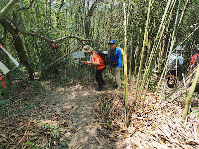
The trail was mostly under trees but we felt heat. By the trail a stone resembling a bamboo shoot is sticking out of the ground, beside which a sing was attached to a trunk. After several short ascent and decent along the ridge, we came to a junction at 10:50. This is where our route turns 90 degrees to northward. After coming down for a while, we entered bamboo grove and came to a junction. There was a pile of of young bamboo peel by the junction. This means that people are harvesting bamboo shoots. Two of our members were eager to harvest bamboo shoots so we stayed there for twenty minutes while they were working on bamboo shoots. This is another kind of fun for the hike.
 |
| Junction of turning direction |
 |
| An open space covered with fern |
 |
| Junction midst of a bamboo grove |
 |
| Climbing to Wanggong-shan in another bamboo grove |
 |
| Summit of Wanggong-shan |
The trail goes down a short while and up again for about 150 meters in height to our next peak Mt. Wanggong-shan (王公山). The trail again goes through a bamboo grove. We reached the summit (elev. 280m) at 12:00. It felt occasional breeze. We had a lunch break on the summit under trees.
 |
| Going down a steep section |
 |
| Going through rock tunnel |
Our next section started with a deep dive with metal ladders and ropes, then hit a naturally formed rock tunnel called Yixiantian (一線天, meaning slit sky). This is an attraction of this route. We went though it with excitement and further down. Passing a junction at the bottom we climbed back to the highest point of our hike, Mt. Xinanjian (溪南尖山, elev. 301m). On our way up we met a hiker with a sickle in his hand. He looked like a local hiker who maintains the trail.
 |
| Climbing back to Mt. Xinanjian |
 |
| Rest place by the summit |
At 12:54 we reached a small flat place with benches and a covering sheet above. This is a resting place built by local people. We had a short rest and had nice cool bear that our member shared with the rest of us. The summit is just next to the resting place. There are two stone markers and a old-looking tall direction sign. The sign was there on my last visit.
 |
| Summit of Mt. Xinanjian 8 years ago, |
 |
| Going down from Xinanjian |
The way down from Xinanjian is also very steep. We passed a steep slope with ropes and down to a wide track section. In about a half hour we came out of woods and an open area, which soon met the trail head by a paved road. Passing a gate of a Buddhist temple Nantiansi (南天寺) a small Tudigong shrine stands on our left. We washed our hands and face at the shrine, and went to a nearest bus stop Lincuo (林厝站). In a couple of minutes came a #Blue 95 (藍95線) bus.
 |
| Another remaining old sign |
 |
| Trail head |
 |
| Gate of Nantiansi temple |
---------------------
 |
| Common Melastona in bloom 野牡丹 |
We spent nearly 6 hours including rests. It was a bit longer than I expected. It was due to longer rests during the hike. It is not a problem. We hiked for fun, not for training. Two members had a good harvest of bamboo shoots too 😊The distance was a little more than 7 kilometers with a total ascent of 480 meters, which equals to the course physical index 17.


0 件のコメント:
コメントを投稿