|
| Mangjituan hike at the starting point, 68 members |
台北市の最高地点を擁する陽明山山系の七星山は、ハイキングの対象として人気がある。好天の山頂は、さしずめ街のマーケットの様に混雑する。記念写真を撮るにも大変だ。多くのハイカーは、冷水坑或いは小油坑から登り反対側に下る。きつい登りになるが、苗圃登山道を経て来る登山者も多い。しかし、こうした石畳の国家公園管理下の道とは別に、登山者が開いた土の道があり、石畳道では行けない場所に続く。道標などや保護設備はほどんどない。道を知っていないと、なかなか入りにくい。筆者はすでに歩いているが、今回慢集団のメンバーを案内した。また、しばらく訪れていなかったので、山道の最新状況確認のため、慢集団活動の直前に歩いた。日本語の記事はすでに載せているので、今回は英語で記述します。
===================================
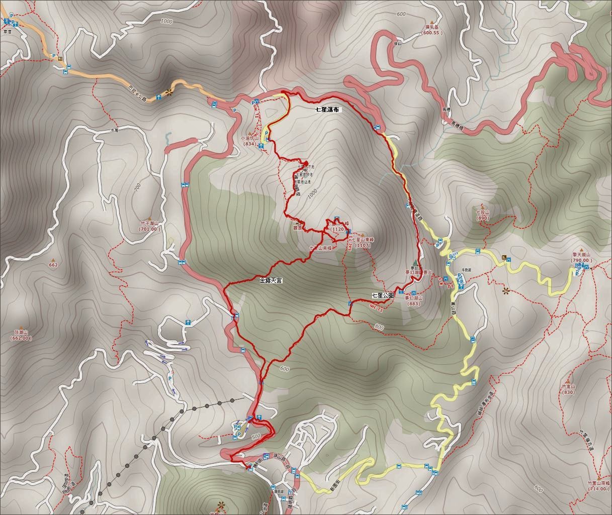 |
| A round trip around Mt. Qixingshan |
 |
| Hiking elevation profile |
 |
| Looking at the south peak from the visitor center |
Mt. Qixingshan (七星山) of the Yanming mountain region is, with its elevation of 1,120m, the highest point of Taipei city. This mountain is located in the center of the Yanming National Park and has good hiking trails going over it. Most of hikers climb ether from Lengsuikeng (冷水坑) or Xiaoyoukeng (小油坑) and go down to the other end. There is also a strenuous trail from Miaopu (苗葡). On a fine weekend day the peak is crowded with hikers and you have to wait for your turn to take a picture. While most of hikers are happy with a good view from the peak and enjoy good walking on the stone paved trails, there are a few interesting spots only accessible by unofficial dirt footpaths. These footpaths are not maintained by the park authority and there is no direction signs or other protective measures. You have to have a good knowledge of local geography and sense of direction if you want to follow these footpaths.
 |
| The area of Kaidagelan ancient altar, there is a pyramid shaped peak in the center (photographed in Mar 2013) |
 |
| Qixing water fall |
In order to share my experiences of visiting obscure spots of Mt. Qixingshan, I guided a group of hikers under an activity of
Manjituan Group (慢集團), which I take a part as a guide once a month. My plan was to start from Yangmingshan (陽明山) bus terminus, go up by a steep dirt footpath to the south peak, visit
the ancient altar of Kaidagelan aboriginal tribe (凱達格蘭遺址) and
Qixing Pond (七星池), follow pedestrian trails (人車分道) passing by Qixing water fall (七星瀑布),
Menghuanhu Pond (夢幻湖) and Qixing Park (七星公園) then back to Yanmingshan bus terminus. It is a round trip going all around Mt. Qixingshan and a rather strenuous hiking plan. At the beginning 68 members started and then a few of them dropped off at the first steep incline. At the bus stop of Xiaoyoukeng, a halfway point of the entire course, a little less than a half of the troop left and went down the mountain by bus. Finally 35 of us completed the whole route, by spending eight hours and a half.
 |
| Steps to Jinlutiangong temple |
We meet at MRT Jiantan station (劍潭站) at 7:30 and then take a R5 line bus to Yangmingshan bus terminus. On a weekend day most of passengers on the crowded bus are hikers. After arriving at the bus terminus, we have a warm-up exercise and a briefing, then start walking at 8:30. We first take the around-Mt. Qixingshan trail to the visitor center. A few members are already there waiting for us and join the troop. We can see the south peak high up behind the visitor center building. We go on our hike and walk on the stone paved trail parallel to the Yangjin highway (陽金公路). We pass by the trail end of Miaopu hiking trail, which leads to Mt. Qixingshan as well. When we pass by an open area at the intersection of a road to Yangmingshuwu (陽明書屋), a footpath on the grass hill just under the south peak is visible up there. We will be there in about two hours.
 |
| Jinlutiangong temple |
 |
| Fallen tree trunk blocks the trail |
At a little past 9:20 We reach the bottom of stone steps leading to a Taoist temple, Jinlutiangong (金露天宮). Cherry flowers are in full bloom by the stair case. This route is apparently only walked by hikers like us and steps are green with thick moss. It gets slippery if it is wet after rain. The incline is pretty steep and we start feeling hard work going up. Fallen tree tanks get in our way at a couple locations. After twenty minutes of strenuous uphill we reach a secluded flat area where the temple is located. We have some rest and wait for all members coming up. During the climb up here a few members felt too hard for them and left the troop.
 |
| Climbing in woods |
At 10:00 we start going up. This is a junction and another narrow dirt path goes right leading to the Miaopu trail. The climb here is not easy either. Aiding ropes are affixed at a few points to help hikers going up a steep incline. A hard labor of 15 minutes or so bring us to a little hump and just below it another path diverges. We take a right one. This footpath is even more primitive. We walk a hillside for about 10 minutes and comes to another junction. We take left here to start uphill. The right one goes all way to the Maopu trail and you can go up directly to the Kaidagelan ancient altar from another junction at the halfway point if you take left there. Two friends and I took this right way just two days ago and went up to the ancient alter directly.
 |
| Steep climb in grass |
The footpath leading directly to the south peak is not so popular but compared with other unpopular routes that I have ever walked, it is pretty clear and you won't miss it unless you are careless about where it leads. At 10:37 the footpath merges another footpath from right, and we leave woods and go into a thick grass section. As we climb a steep dirt path, we can see a wonderful view over tall grass walls if we turn our head around. You have to grab the grass besides the path because it it pretty steep and slippery. Through a half hour of struggle we come to a moderate part of the climb. The summit is already not far. A big rock is just beside the footpath. You get on there and have a spectacular view; the weather is wonderful and the air is so clear that you can make out Mt. Xueshan (雪山) mountain range far in the distance floating over clouds. In front of the Xueshan range you can identify those mountains in Sansha (三峽) and Fuxing (復興) districts like Mt. Beichatian (北插天山) and Mt. Lalashan (拉拉山).
 |
| Panorama from a point just below the south peak |
 |
| Xueshan mountain range is visible far in the distance above clouds |
We finally reach the summit of the south peak at 11:10. Just across a depressed area you can see the main and east peaks. There are many hikers visible on the two tops but here are only our members though we ourselves are as many as 63. After all members reach the top, we start going down. A few minutes descent and out from the narrow dirt path we pop onto a stone paved trail. This is a park official trail connecting Xiaoyoukeng and the main peak. We take right and soon come to an opening on the bamboo wall. This is an entrance to the ancient alter. We go into this dirt footpath between the bamboo walls. Just a few minutes and we come to an area of the ancient altar.
 |
| View from the south peak, the main peak in the center and the east peak on the right |
 |
| One of the special rocks, dinosaur rock, in the altar area |
So called Kaidagelan ancient altar is a series of strange shaped rocks discovered in an encircled flat area just beneath the south, main and east peak. It is said that Mr. Lin, a descendant of the Kaidagelan ancient tribe, discovered this by chance more than a decade ago. He says that these stones are man-made and the tribe people used to come here to pray for god. A place named Qixingtui (七星堆) is, according to him, the altar. There is a pyramid shaped little peak closer to the edge of the area and visible from the altar. It is said to have served as a guide for a UFO of aliens who left the tribe high level civilization. Huge rocks are piled up one upon another in a very orderly manner like stones of a pyramid. Later geology scholars came in and studied the area. They concluded that these stones are naturally formed in the process of volcanic activity. There is no conclusion to this so far, though. Whichever it is, the place is special and worth visiting. We have lunch around the Qixingtui as the time is 12:00 noon.
 |
| A small opening of the footpath besides the stone trail |
We have a long brake of a half hour and start for the main peak. At the east end of the area we climb up a steep narrow path covered by thick bamboos. A few minutes uphill and we popped out onto another stone paved trail where many hikers walking. This is the official Miaopu trail. The opening we have just come out is very small and most hikers would not notice there is ever a footpath here. We take left turn and go up to the top of main peak. Today is a beautiful Saturday and many hikers are on the top. We take pictures in turn. The view from here is also very good. You can see the coast town of Jinshan (金山) down there between the peaks of Mt. Zhuzishan (竹子山) and Mt. Huangzuishan (磺嘴山).
 |
| A view from the main peak, Jinshan is down beyond the valley, Mt. Zhuzishan (left) and Mt. Huangzui are visible |
 |
| Going down Zhaixingpo footpath |
We start for the next spot on the list, Qixing Pond (七星池). We walk down the stone trail to the half way towards Xiaoyoukeng. Just passing sulfur smoke emitting holes we find a opening of a footpath on a grass wall besides a tree. This footpath is called Zhaixingpo (摘星坡), meaning star picking incline. This path goes along the edge of a cliff overlooking three pools of water in the valley, Qixing pond. We stick our head into the grass tunnel and swim through it. This is another grass covered footpath today. We go very close by smoke holes and start a moderate descent. I tell people to follow closely behind their front trooper not to get lost. Your vision is blocked by grass covering the path, so you need to look down and make sure you stay on it. It seems that many of members have never experienced this kind of footpath but they are enjoying it.
We start very steep descent and come down to meet another footpath from left. We arrive at the pond at 14:30. Water has evaporated completely due to a little rain in the recent weeks. It was the same two days ago when I came here for study the latest situation of unofficial footpaths. Now it is just a flat open space in a deep valley.
 |
| Group shot at Qixing pond |
 |
| The dried out Qixing pond |
 |
| Thirty some members keep on hiking, at Xiaoyoukeng |
After a short rest we resume our hike down to Xiaoyoukeng. Passing through another dirt footpath in the tall grass we come out onto the paved hiking trail. We walk down stone steps and at 15:00 we arrive at Xiaoyoukeng. It is more than an hour behind my original schedule to reach here. I tell members that we have to walk faster for the rest of today's route. Nearly 30 members feel tired already and leave the troop for a bus ride down. The rest of us, 35 members start for the next spot Qixing water fall. We first walk along the car road to an observation platform where the stone paved trail meets. We take the trail to go down and walk to the point where the waterfall is in front. The water over the fall is not much today.
 |
| Keep on the paved trail for Menghuanhu pond |
We then climb steps to a higher level of the trail parallel to the Yangjin highway beneath. You can have a good view overlooking the valley below and Mt. Zhuzishan across it. We walk really fast now to make up the delayed time. We have only two more hours before the sunset. The members are very vigorous and cooperative. After passing the kilopost of 7km on the trail at 15:40, we come onto a car road as the pedestrian trail ends The road keeps going up and it feels rather hard after a walk on a flat trail for sometime. We come to a junction of a road leading to Menghuanhu pond and take right. It keeps going up. Mt. Qigushan (七股山) and
Qingtiangang (擎天崗) are visible from the road. Mt. Qixingshan already casts a large shadow over the parking area of Lengshuikeng. At 16:00 we come to Menghuanhu pond. Water in the pond is almost dried up and the bottom is visible.
 |
| Mt. Qigushan, Qingtiangang is visible beyond the car park below |
 |
| Menghuanhu pond has almost no water |
 |
| Take left for Qixing park |
We continue on the road and go up a little more to a junction. The hiking trail on the left goes down to Lengshikeng. A few friends leave the troop and go down. The rest of us take the right one and go down to Qixing park after passing another junction where a trail goes up to the east peak. We arrive at the park at 16:15 and take a final rest. The sun is casting a yellowish late afternoon light over the wide park area. This is a happy moment for all of us, recalling all scenes of the hike today. After a rest we start on the paved trail all the way down to the visitor center where we reach at 17:00 and end a hike of 8 hours and half covering 12km of distance.
 |
| A final group shot at Qixing park |
The route we walked is not for all hikers. The fast half up to Xiaoyoukeng is to walk on non-official dirt footpaths and I recommend only to experienced hikers. There is very little aid like direction signs or ropes. The second half is a good park official trails and good for any hikers.
----------------------------
Additional note
 |
| Hiking route of January 22 |
On January 22, two days before the above group activity, I walked almost the same route for the first half of the Jan 24 hike. While we walked on the north side of Mt. Qixingshan after reaching Xiaoyoukeng on January 24, I went back to Yanmingshan bus terminus by the west side trail. See the map right for comparison. The unofficial section of footpaths are not always as good because there is no regular maintenance. It is only good as long as hikers keep walking. It deteriorates very quickly if there is few hikers walking. You are recommended to study a latest situation of footpaths over internet or by some other means before you actually go there.