 |
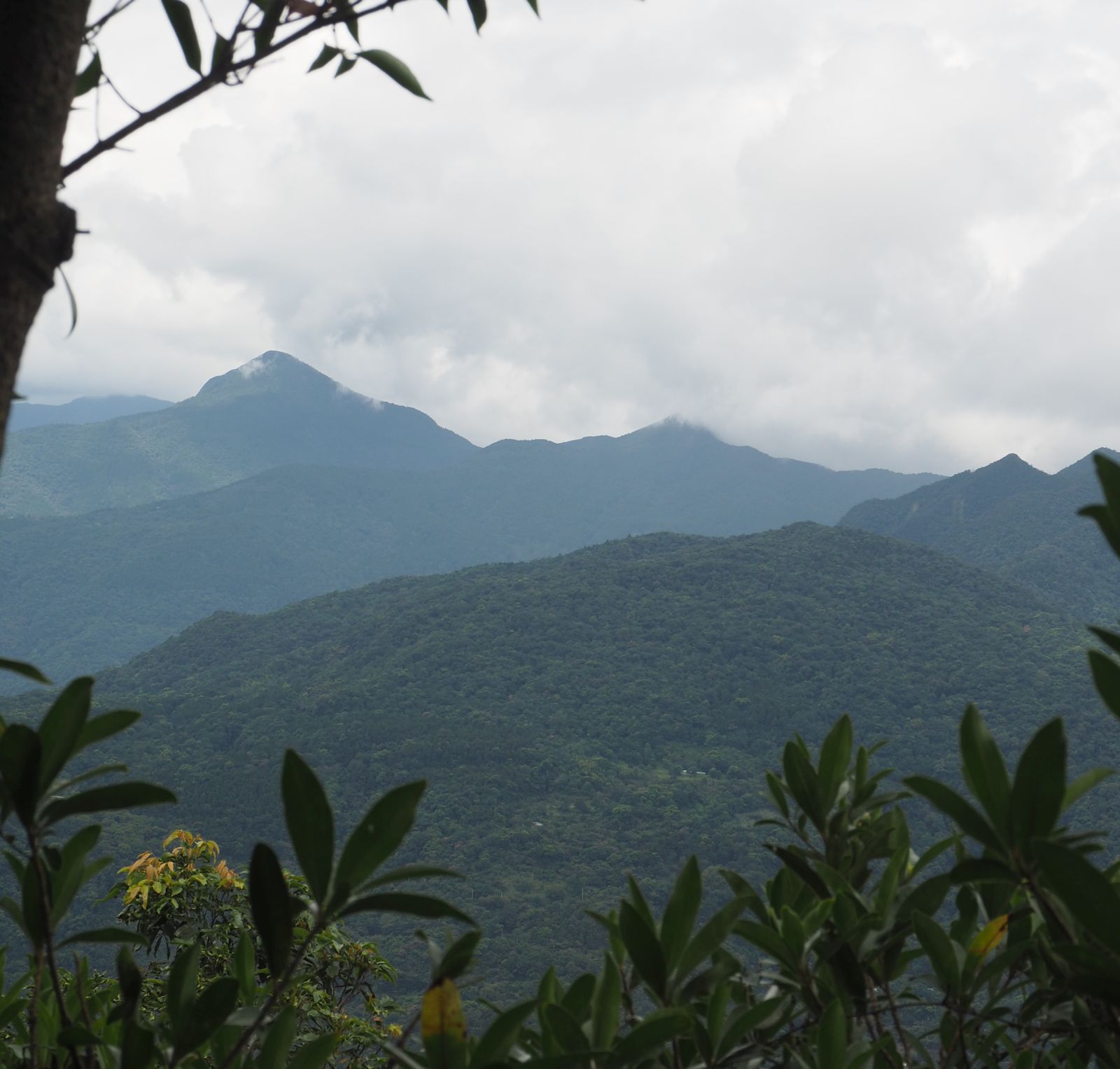
| Mt. Datong-shan and Mt. Wulai-shan in front by Wulai Town viewed from near Mt. Dabaoke-shan(Aug 2013) |
今回対象の烏來山から大桶山への縦走は、実は
9年前に一度歩いている。その時は一人で登った。今回は、新コロナウィルスの警戒3レベル間の非活動期間の登山体力後退を取り返すため、登坂能力向上を目的に歩いた。台北ハイカークラブのメンバーを含めて都合9名での山行である。昼頃1時間半にわか雨に降られたが、前後は気温的には少し楽だったかもしれない。移動中は汗がとどまることがなかったが。水平距離1.4㎞で700mの落差を稼ぐ烏來バスターミナルから烏來山前峰のセクションは、一部緩い部分もあるが、ほとんど途切れることのない急勾配の山道で、岩の部分や狭い尾根もあり苦労する。それが目的でこのルートを選んだ。 四崁水山を経て桂山路へ下る部分は初めて歩くが、今回は英語で記述します。
===========================
 |
| At Mt. Wulai-shan summit |
Mt. Datong-shan (大桶山, elevation 916 meters) stands high on the right bank of Nanshixi river (南勢溪) as if being a gate keeper of Wulai town (烏來). Standing next to this peak Mt. Wulai-shan (烏來山, elevation 820m) looks like an auxiliary to Mt. Datong-shan, but its peak is protected by a steep uphill from the bottom to its front peak (烏來山前鋒). If you want to take on this peak you have to climb an unbroken precipitous trail of 700 meters in altitude with an average grade of 27 degree and 39 degree at the steepest stretch. This is exactly why we made a hike over this route. We wanted to enhance our capability of climbing.
 |
| Hike from south to north |
As the Covid-19 alert has been set down to level 2, we have more room to do our hiking. The two-month complete absence from hiking degraded our uphill capability. This hiking was intended to regain and improve our physical strength for climbing.
I made a hike of over these two peaks nine years ago and remembered what the route was like. We followed the same route except the last part, which we deviated from the official trail of Mt. Datong-shan and went down to Guishanlu road (桂山路) by way of Mt. Sikanshui-shan (四崁水山), instead of Zhongzhi village (忠治村) where the official route leads to.
 |
| Mt/ Datong-shan viewed from a bus window |
Talking about Zhongzhi, this community was and is a village of Atayal indigenous people (泰雅族原住民) and originally called Tampya in their language. Until the very early 20th century the valley of Nanshixi river was a territory of the indigenous tribe. The village on the lowest point of the river was Quchi (屈尺). Several villages spotted at upstream of the river all the way to the current Fushan (福山, Limogang in their language). These villages were given new Chinse names of abstract meaning after KMT government (國民政府)took over Taiwan. This kind of naming irreverent to the indigenous culture was made to almost all villages of indigenous tribes all over the island. It is a kind of injustice to or denial of their cultures by the government of the time.
--------------------------------------
 |
| Nanshixi River by the side of Wulai bus termnius |
Our meeting point is Wulai bus terminus. Originally we intended to take a second earliest bus from Taipei Gonguan (公館) which was supposed to leave Gonguan around 6:30. Five of us had to wait until 7:15. This was also a temporary time schedule due to the pandemic, which we did not know because no official announcement was available. Eventually we got to Wulai at 8:10 to join other members who had come earlier by themselves. The sky is blue. The Nanshixi river by the bus terminus is full of water from bank to bank. Obviously heavy rain caused by Typhoon Lubi (盧碧颱風) last week left such volume of water.
 |
| Trail head on the left |
 |
| The trail soon turns very steep |
The trail head is just next to the bus terminus. Nine of us set off at 8:19 and go under the gate of Miaoxin-si tample (妙心寺) to ascend one or two minutes. The trail head on the left low concreate wall invites us to go in (elevation 135m) . The first section is a path to a water supply system. We see big silver metal tanks on our right. Our trail soon diverges to the right while the other path goes along the valley. The trail is clear but pretty steep climbing in a lush vegetation. While the temperature should be not so high yet, we soon find ourselves sweating from head to feet.
 |
| Rock shows on the surface |
 |
| Get through this shrubs |
As we ascend, we come to sections of bear rocks showing on the track surface. Ropes are fixed to such points to aid us to safely pass. At around 8:50 the trail suddenly comes to a blockage of a big fallen tree trunk. This must have happened recently because the track to detour the blockage is not clear. We have to duck under shrubs and pass by thorny plants to get clear of this. We keep on the steep climb for another 15 minutes or so and come to a small flat open place (elevation approximately 460m) at 9:09 where we have a first rest. We have came up about 330 meters in height.
 |
| Bare rock section |
 |
| Viewing the valley through vegetation |
A steep climb of about 20 minutes brings us to a gradual section and even a short downhill which give us a short time to take easy breath. The ridge we traverse gets narrower and bear rock sections show up one after another. Two of the members walk slow and lug behind. I shuffle the position of our troop to place them just behind of me so that I can watch them and proceed by their pace. My policy is to keep our members in a unseparated troop to ensure safety. A member suddenly suffers muscle cramp just below one of such rock sections around 9:53. I decide to take a rest as there is a enough space for the all members to have a rest.
 |
| Climbing a rock section |
A 15-minute rest proves enough for him to be OK. We keep struggling the precipitous trail for 25 minutes and reach the front peak of Mt. Wulai-shan (烏來山前鋒 elev. 789m) at 10:42. On our way up here we have an open view of the west direction. The peaks of
Mt. Kabao-shan (卡保山) and M. Zhulu-shan (逐鹿山) are identifiable. On my last visit here on the front peak I had a nice view of the same direction, but now a thick vegetation blocks any open view. Nine years have since brought a big change. We have covered three forth of the total height to Mt. Datong-shan and have a rest of 15 minutes at the small summit.
 |
| Viewing Mt. Kabao-shan (left) and Mt. Zhulu-shan |
 |
| The summit of Mt. Wulai-shan front peak |
 |
| A narrow ridge to the main peak |
Our way to the main peak of Mt. Wulai-shan starts with a downhill. It soon turns to a steep climb but does not last long. We reach the summit at 11:15 though the member has cramp again on the last stretch to the summit. Other members help him to recover like giving him massage, which is really nice. The summit of Mt. Wulai-shan is encircled by trees except one direction, through which you can have a view of a massive body of Mt. Datong-shan and a distant view of Taipei on its left. The summit of Mt. Datong-shan has an antenna tower sticking up over the forest canopy. The distant view is hazy but you still can make out the community of
Dataipei Huacheng (大台北華城) on the slope of Mt. Tutan-shan (塗潭山).
 |
| Mt. Wulai-shan summit |
 |
| A view from the summit |
We continue our way to Mt. Datong-shan without a rest. . Returning from the summit to a junction just below the summit we turn left to follow the trail. The elevation profile between Mt. Wulai-shan and Mt. Datong-shan is a kind of saw blade with small ups and downs. We go up to the top of narrow ridge where you can have a view of Mt. Datong-shan. Cloud is gathering over its summit and the overcast sky is getting darker.
 |
| There is still a distance to Mt. Datong-shan |
 |
| A old broken direction sign |
The narrow ridge is getting wider and we pass by an old direction sign. The direction arm is off on the ground. I remember it was attached to the pole on my last visit. The trail then turns a direction to the right and takes on the hillside ahead. As we go up the last ascent to the summit, rain start falling. It soon turns very hard rain. We put rainwear and continue our last climb to the summit. We reach it at 12:27.
 |
| Finally reaching the summit in heavy rain |
 |
| At the summit of Mt. Datong-shan |
 |
| Rain water is running down along the trail |
We have a rather miserable lunch at the summit in hard rain and leave at 13:00. The peak of Mt. Datong-shan was once described as a back of a whale. The first stretch of our way down the mountain is rather flat. At the junction to the east peak and farther to
Mt. Luofeng-shan (落鳳山), the trail makes a left turn and goes steeply down between cedar trees. Water is running down along the trail like a creek. About 15 minutes decent takes us to a less steep section where plank steps are placed on the trail. Soon after passing a junction diverging a trail to the right at 13:20, we come to a spot where distant mountains are visible through branches. Rain has almost stopped falling by now and we take off our rainwear.
 |
| Mist is clearing over the distant peaks of Chatianshan range |
 |
| Incorrect words of the sign |
Several minutes of decent bring us to a spot where we can have a view of Chatianshan mountain range (插天山脈) from
Mt. Badaoer-shan (拔刀爾山) down south to
Mt. Lepei-shan (樂佩山). Mists are clearing from the peaks. We keep on the good trail down which is covered with weeds at some points. Clouds are clearing and blue sky is back again. Cicadas are now loudly sounding. As soon as the trail levels off, the junction to Mt. Sikanshui-shan shows up at 14:00. We have a good rest there to compensate the miserable rainy break at the summit of Mt. Datong-shan.
 |
| The junction to Mt. Sikanshui-shan |
 |
| Mt. Sikanshui-shan summit |
 |
| Trail cleared by Lantian-tui hikers |
Having spent easy 25 minutes at the junction, we set off for our further way down. The trail goes on the ridge while the official trail goes down on the left slope. A steep decent leads to a junction where a trail diverges directly down to Guishanlu road. We follow the ridge trail which was cleared by volunteer hikers a year ago. It goes up a little and takes us to the summit of Mt. Sikanshui-shan (elev. 565m). A triangulation marker is in the center but no view as it is surrounded by tall trees. The last section of the trail is somewhat in sad shape. You have to duck under tall grasses to get out into a forestry field affiliated to Chinese Culture University (中國文化大學). The forest field looks a little dilapidated. Elevated plank walks are left in decay. Explanatory boards by the road are left broken and letters are unreadable. We come down to the gate at 15:10 and have a break in front of it.
 |
| Gate of the forest field |
 |
| Walking down along Guishanlu road |
The last leg of our hike is carefree: just walking down approximately 3 kilometers of the paved Guishanlu road.
We once walked down on this road three years ago. As we come down for about a kilometer, the peaks of Mt. Niuzui-shan (鳥嘴山) and Mt. Chijiaolan-shan (赤腳蘭山) stand across the valley, over which
we hiked just a couple months ago. Passing the 1K milepost of the road a New Taipei Community bus (新巴士, free of charge) is coming down. We take a short ride of it to Guishanlu (龜山路) bus stop, which saves our last 1 kilometer or so of walk. We take off the community bus at 16:16 and wait for about 20 minutes to aboard a #849 bus back to Taipei.
--------------------------------------------
 |
| White Crane Orchid (白鶴蘭) by the trail |
It rained for an hour and a half in the afternoon, so the overall temperature is not that high. Even so sweat never stopped. By the time we reach the gate of forestry field, everybody was soaked wet of rain water and sweat. The distance we hiked was approximately 9 kilo meters with a total ascent of 947 meters and decent 959 meters. With the total time of activity including breaks 7 hours and 50 minuets, the route physical index is 27. This number may be a little deceiving because the precipitous section in the first half of the hike is not easy. The trail itself is in good shape except the final section of Mt. Sikanshui-shan. If you want to train yourself for stamina of ascent, this could be a good candidate for your training.


0 件のコメント:
コメントを投稿