 |
| 北五指山草原から基隆方向を望む |
陽明山山系は、台北盆地の北側を600~1100mクラスの峰々で囲む。山系北側にある海岸地区との間の障壁でもある。萬里は陽明山山系と五指山山系から流れ出る瑪鋉溪の河口にある街で、近くには漁港がある。瑪鋉溪を遡り風櫃嘴の峠を越すと台北に入る。この道は北28号県道になっている。瑪鋉溪の北岸は、陽明山山系の草原を有する山々で、その昔はかなり奥地まで人々が居住していた。
今回の山行は、数年前に歩いた大尖山から伸びる稜線やその谷間の居住跡を巡り、大尖山を登頂、そして山越えをして台北側の北五指山草原を経て下った。再び訪れた、富士坪草原は、背の高い草がだいぶ侵入し、草原の趣がだんだん失われている。本来地元民が農耕のための牛を放牧していた。今は草を食む牛があまりいないために、このような現象になっているようだ。一方北五指山草原は、我々が訪れている間に牛がやってきて草を食んでいた。まだまだ、ゴルフ場のグリーンのような芝の草原が保たれている。初夏の草原は、風も吹き抜けとても気持ちが良かった。
-----------------------------
 |
| All members at Beiwuzhishan meadow |
Yanmingshan (陽明山) mountain range holds several beautiful meadows on or near its ridge lines. They look like green fields of golf courses. The meadows are kept that way by cattle grazing, of course not by mower machines. Caws and water buffalos are roaming the fields, which you often come across during hiking. Our hike passed two of the largest meadows of the range besides Qingtiangang (擎天崗) and let us enjoy very much. Another attraction in our hike this time was to pass by remains of an abandoned tea house beneath Mt. Dajian-shan (大尖山) near Fushiping (富士坪) meadow, which gave us a glimpse of the residents' lives in the past. Under a nice clear sky of early summer, we had a wonderful time.
 |
| From east to west to cross the Yangmingshan range |
------------------------------
 |
| Just arrived at Wanli Qiaotou by #953 bus |
Our starting point, the head of
Fushi trail (富士古道 or Fushiping trail 富士坪古道), is located at Xidi (溪底) of Wanli district (萬里區), Xinbei-shi (新北市) municipality. Wanli lies north of the Yangmingshan mountain range. The mountains block easy passage and all public transportation goes around the mountain range. Each of the participating members took a convenient bus route of 1815, 1062 or 953 and came to the meeting point, Wanli Qiaotou (萬里橋頭). Thirteen of us gathered by 8:45 and took four taxies to head for Xidi. A 15-minute ride took us to the trail head. Each taxi costed NT$275 or so.
 |
| Fushi trail head |
 |
| Reaching the shrine on the hill |
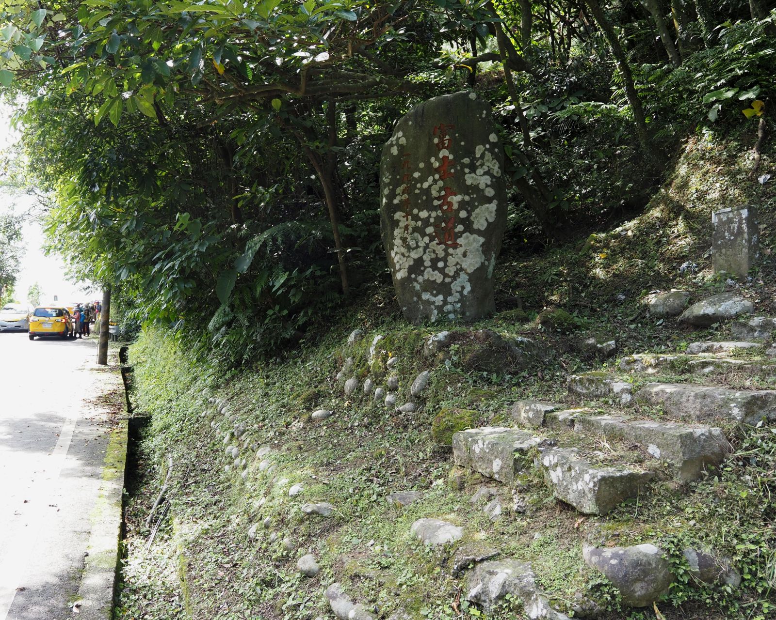
A large stone monument engraved with "富士古道" stands by the trail head. The first section starts with stone steps and was built thanks to a donation of a local person. A small stone memorial stands by the trail to commemorate his contribution. The step trail leads up to a little Tudigong shrine (土地公廟) on a hill. The shrine was renovated and looks fresh and new. The Fushi trail goes further down to the abandoned Xidi primary school and beyond. We take a narrow trail of Tudigongkeng (土地公坑古道) instead, which starts just by the shrine hut.
 |
| Flat Tudigongkeng trail |
 |
| Crossing Tudigongkeng creek |
The trail goes along the mountain side with very few ups and downs. Several water tubes of large and small go along the trail. We come to a point to able to see a small water fall in fifteen minutes from the shrine and soon cross a stream of Tudigongkeng-xi (土地公坑溪). The trail then goes up a little and down to the ruins of a large abandoned house at 9:51. A new small plate shows that this house belonged to Lai family (賴家). The size of the ruins suggests that they were a large family at that time.
 |
| Descending trail |
 |
| Abandoned house of the Lai family |
 |
| Passing through abandoned terrace paddies |
 |
| Climbing along a stream |
After a short break in front of the ruins, we resume our hike. Our trail soon passes by several levels of abandoned terrace rice paddies. Trees and bushes here and there cover them now but the landscape reveals their original formation. These paddies must have belonged to the Lai family. At the end of the terrace paddies the trail turns the direction and goes up along a small stream. It then leaves the valley and go up by a very steep track onto a branch ridge.
 |
| Primitive stone steps |
Along the trail find sections of primitive stone steps, which must have been laid by local people of the time. A short length of the trail is covered with yellow rotang palms (黃藤), but for our goodness their thorny branches have been cut out by volunteers. Otherwise we would have a hard time passing this section. At a little before 11:00 we pass over the highest point and go down a little, passing a cedar tree encircled place called Laoying-gu (老鷹谷, meaning a valley of eagles) and then meet another trail called Lukuping trail (鹿窟坪古道) at 11:04.
 |
| Thorny rotang palms hanging over the trail |
 |
| The highest point on the Tudigongkeng trail |
 |
| Laoyinggu valley |
 |
| Going along Lukuping trail |
At the junction we take left and start ascending towards Fushiping meadow (富士坪草原). The trail moderately gains height and reaches a junction at 11:06. We take a trail coming up from our left and go down. This trail goes along the mountain side and passes by abandoned villages. In a few minutes the trail levels off and passes by a flat open platform. Several empty bottles of various side and color are placed at the edge of the platform. There is no remaining building materials around, but this is a place where once houses stood and people lived.
 |
| Direction markers for Dajian Chahang house |
 |
| Remains of a abandoned house, note bottles on the platform |
 |
| Going on the trail |
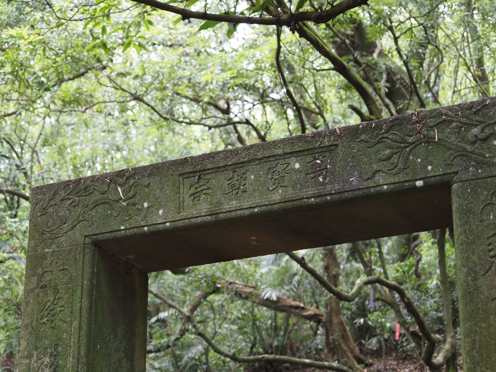
We keep on the trail which goes up and down a little. Abandoned terrace paddies show up as we go along. At 11:40 we come to a fork and see the ruins of Dajian Chahang (大尖茶行) tea house just beneath the fork, to which we go down. Stone door frames still stand with low stone piled walls. The frame of main door is engraved with phrases like "萬寶朝宗" and decorations, showing how glorious this house was in those days. The front platform was build up with a tall stone retaining wall and filled up with earth. This was a large construction then.
 |
| Ruins of Dajian Chahang house |
 |
| Door frames are still standing |
 |
| Engraving on the main door frame |
 |
| Stone pavement |
At 11:56 after a break of ten or so minutes in front of the ruins, we go up from behind the ruin and take another trail at the fork. A short stretch of the trail is paved with stones, which are now all covered with green moss. We pass by another remains of houses and cross a small creek. The trail gets wider and splits a trail going up on our right. We take this forked trail and get onto the Fushi trail. If we had not taken the Tudigongkeng trail in the morning and taken the Fushi trail instead, we would have been here much earlier. In other words, we made a long detour, but it is well worth.
 |
| Crossing a creek |
 |
| Simple Taoist shrine |
 |
| Climbing to the meadow |
We follow the Fushi trail, which soon merges a trail from the left. This trail is called
Ruiquan trail (瑞泉古道), which I travelled several years ago. At the junction there is a little Tudigong shrine, in which a small Taoist deity and incense pots are placed. People sill worship at this remote shrine. The trail gets into a valley and go up steadily, which come out onto an edge of the Fushiping meadow at 12:27. There is a trail going up on our right and we follow it to the summit of Mt. Fushiping-shan (富士坪山, elevation 640 meters). The trail goes down from the summit and out onto the meadow again, where we have a lunch break by a pond.
 |
| Coming out onto Fushiping meadow |
 |
| At Fushiping-shan summit |
 |
| Mt. Huangzuishan over the meadow |
The May sun is already strong, but by staying under trees with occasional breeze we have a nice lunch for a half hour. We resume our hike at 13:05. The flat field that we are traversing is supposed to be a meadow, but so much of tall grasses cover it. The meadow is being taken over by grasses. In the old days local farmers take their water buffalos to the meadow and let them feed on grasses. There are very few cattle roaming this area and that may be a reason for this phenomenon. Over the meadow stands a big belly of
Mt. Huangzui-shan(磺嘴山) |
| Junction with a direction sign pole |
 |
| Looking back at the meadow |
The trail comes to a junction on a small meadow with a tall direction sign pole. We take left one and go along the side of Mt. Dajian-shan. It gradually goes up and reaches a small meadow on the ridge. This is also a junction for the summit of Mt. Dajian-shan. All but one of us take the left trail and climb to the summit. There are a couple of very steep sections with aiding ropes. As we go up, the grade becomes less steep. We finally reach the summit at 13:40, which is the highest point of our hike. The summit (elev. 837m) is surrounded by tall grasses. However large boulders are nearby and you can get an unobstructed view of all directions from the top of them.
 |
| The peak of Dajian-shan is ahead |
 |
| The summit isn't far |
We have a very clear sky today and can enjoy as far vistas as Jilong (基隆) by the ocean and mountain ranges behind its town. Mt. Huangzui-shan and
Mt. Dahoujian-shan (大後尖山) which we visited last November show their large body side by side in the north. In the west finds a long range of Yangmingshan peaks like Mt. Qixing-shan (七星山), Mt. Shitiling (石梯嶺) and so on. We take the same trail back down to the junction. After a short break we further follow the Fushi trail to the main hiking trail of the Yanmingshan Park, which we reach at 14:48.
 |
| Dajian-shan summit |
 |
| Panorama from the top of bulders |
 |
| Vista towards Jilong |
 |
| Back at the junction |
 |
| Looking back at Mt. Dajian-shan |
 |
| Fushi trail going through cedar forest |
 |
| Come out to the official trail of Pangmingshan Park |
 |
| Walk along the trail for a while |
Compared with the trails that we have come through, the stone paved official trail is very good but boring. A quarter-hour walk brings us to a fork to Beiwuzhishan meadow (北五指山草原), which the official trail does not reach. Passing by a warning signboard saying beware of roaming cattle, we leave the official trail.
 |
| Warning signboard |
 |
| A beautiful meadow |
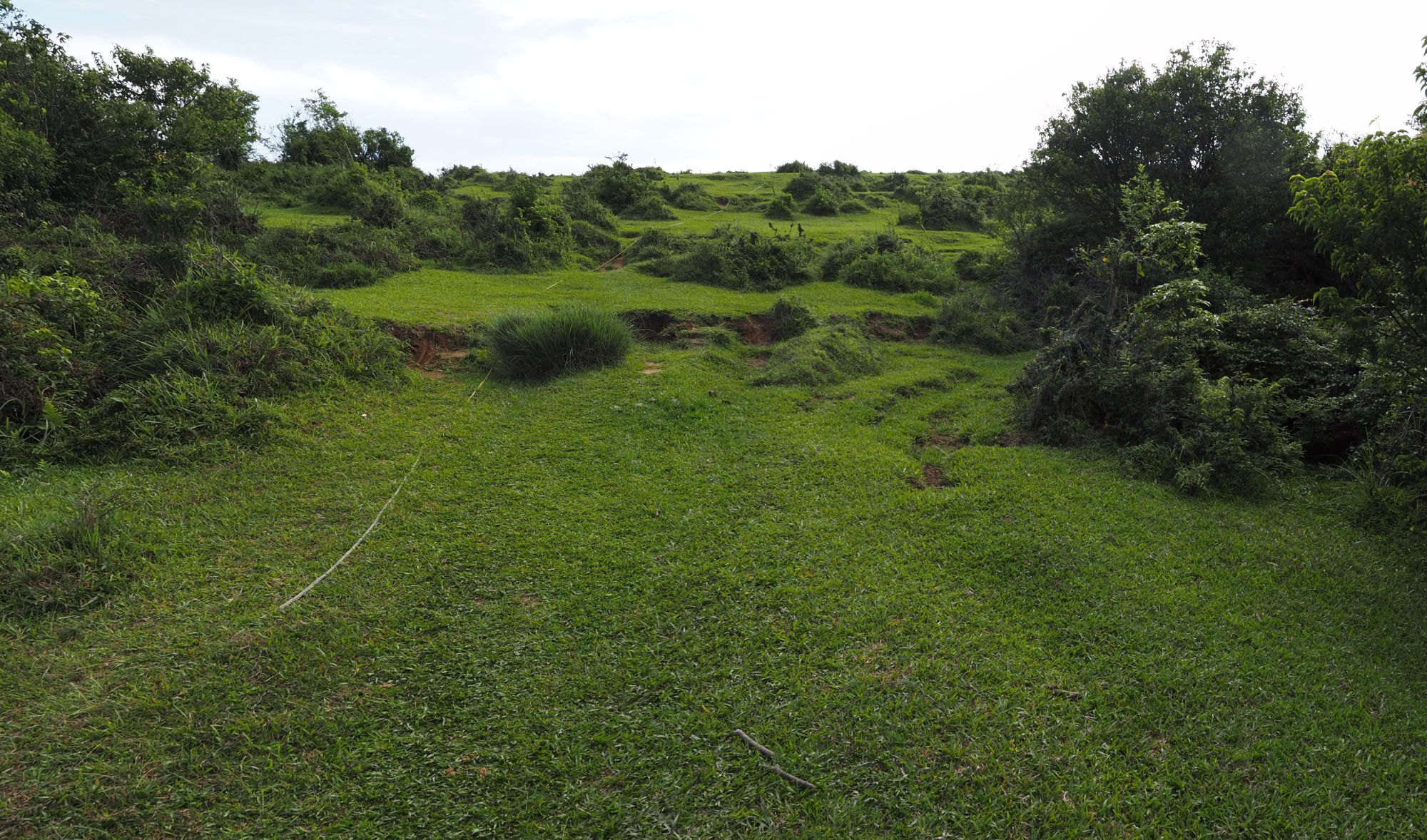
As soon as we step out of the official trail, we find ourselves on a beautiful green meadow. We follow a track on the meadow and go up to a higher level through a section of bushes. This is the wide and flat meadow of Mt. Beiwuzhi-shan. Breeze sweeps over the meadow. For our final break today, almost all of us lei down on the grass and have a short nap. How comfortable it is!!
 |
| On to the higher meadow |
 |
| Looking up the blue sky |
A nap of twenty minutes has made a great job. Most of the members look refreshed and pretty ready for the last leg of our hike. We cross the meadow towards the summit of Mt. Gaoding-shan (高頂山, elev. 787m), which in fact is a little hump on the edge of the meadow. The marker stone that we saw on our last visit two years ago is missing. The earth around the original position has been dug up, which suggests that somebody took the stone away. The trail soon leaves the meadow and dips into woods.
 |
| Taking a nap (a member's photo) |
 |
| Looking over Taipei metropolitan |
 |
| The summit of Gaoding-shan |
 |
| At the edge of the meadow into woods |
We follow the trail called
Helan (荷蘭 meaning Holland) trail down, which connects the meadow and Wanxi road (萬溪產道) at the foot of the mountain. It has two separate routes in its upper half, one going on the ridge and one going along a valley. We take the ridge route. Since
I first visited this route more than a decade ago, it has become a popular route and the track has turned very good.
 |
| Junction on the ridge route |
 |
| Coming down to the valley |
At 16:06 we come down to a junction, where the Helan trail goes down to the valley. A thermometer is attached to a tree trunk by the trail and it indicates 22 degree. The way down to the valley is rather steep and we reach the bottom in ten minutes to meet the other route of the trail system. The rest of the trail goes along a creek to a coffee shop by the Wanxi road, which we reach at 16:30.
 |
| Going down steps |
 |
| Bus stop at last! |
We further go down along the paved road to the head of Pingding Guchou trail (坪頂古圳步道) and take the trail to Zhishanlu road (至善路), then all the way down to Pingding Guchou bus stop where we reach at 17:00. A xiao 18 line (小18線) bus comes along at 17:10 for back to the town.
--------------------------------------
 |
| Author on the grass (a member's photo) |
The meadows of early summer welcomed us with bright sunny weather and comfortable breeze. I love these open spaces with wonderful vistas. It would be well worth just visiting the meadows only, if the weather is fine. You lei down on the lawn-like ground and look up the blue sky with scattered clouds. Gentle breeze touches your cheeks. You may as well fall asleep. What else would you want?
Our hike took us 7 hours 50 minutes to complete including all breaks. We covered 12 kilometers with a total ascent of approximately 700 meters. The route physical index would be 26.


0 件のコメント:
コメントを投稿