 |
| 南港公園から見る南港山 Nangang-shan viewed from Nangang park |
自宅近くからでも望める南港山は、台北盆地の縁を構成する山である。一番近い登山口は、筆者自宅から約5㎞、歩いていける。台湾登山初期に多く訪れた場所である。その後、しばらく訪れることがなかったが、大雨の間欠に訪れた。人里すぐ近くなので、山道は四方八方に続いている。石畳の立派な官製山道もあれば、土の細い道もある。今回はどこを歩くか、大体の地域は決めていたが、その後は実際の状況に応じて適宜変更し、4,5時間の枠内で歩き終えて下山する、という歩き方である。南港山は今までの経験で地理的な条件や道についてわかっていたので、こうした歩きかたでも問題ないことが前提である。
季節が変わりはじめ、台湾北部でもよい天気が現れているが、一方寒の戻りとでもいう東北季節風が吹くと、湿った空気と衝突し、雨を降らせる。ここ二、三日大雨がふった。そして、すぐ訪れる清明節(墓参節)連休の際にも雨が予報されている。そこで、その合間に近場の山歩き、といことだ。結果として、天気は最後にちょっと雨がぱらついたが、良い天気のもと、昼少しすぎには下山した。
 |
| 第2岩壁路 #2 rocky route (2015年) |
数年前によく訪れた、
南港山稜線北側の岩場ルートは、台北市政府によって封鎖され、ロープやアルミ梯子などすべて取り外されていた。そのため、ここは通ることができなかった。台北市のこのような対応は、不適切と思う。ことの起こりは、このルートで死亡事故があったことである。現場にいたわけではないので、事故発生については語れないが、その背後にある誰がリスクをとるのか、という認識において台北市民は、本人ではなく市政府にある、という考えが多いことがその背景だろう。登山は、簡単なハイキングでも、血管系持病などがある人は登山中に問題があることもある。道を歩いていても、車にひかれるリスクはある。様々な行動には、命や財産などに対するリスクが伴う。筆者はリスクはその行動によって利益などを得る本人が、最終的に負うべきだと考える。リクリエーションで岩場を登るのは、それを完成することで本人の達成感などを得るためだ。技術が未熟、悪天候など、本人がリスクを勘案し行動することが前提だ。強制されたのでなく、自主的に岩場に挑みその結果遭難した場合は、本人のリスク判断の結果であって、その道を閉鎖しなかった市政府の責任ではない。死亡された不幸は、同じ登山家として同情にに値するが、その責任は市政府ではなく本人にあると考える。
-----------------------------------------
Mt. Nangang-shan (南港山) is a very familiar mountain to citizens of Taipei, including myself. The peaks and their valleys located east of the Taipei basin are collectively called Nangang-shan. Of course there is a single peak called Nangang-shan. At some of spots not far from my home without tall buildings like open streets, Nangang-shan shows its terrain not afar. This is also one of the places where I first stared regular hikes more than ten years ago. Since then I have been to it many times trying its various routes ant trails. In a few years I seemingly exhausted all major routes of it and hardly visited it again.
 |
| Start from Nangang park |
It is often said that mountains are always there. It is true. After a couple of rainy days I decided to go there and ramble for a few hours on a fine day. I just decided a place to start a hike and a general direction, but not a particular route to follow. So this was a hike that I would decide at a junction which way to go on the spot. I placed my hiking schedule on the
Taipei Hiker Club page of Facebook. It toured out that twelve friends showed up at MRT Kunyang station (昆陽站) of our starting point.
 |
| All members at Jiuwufeng peak |
 |
| Climbing #2 rock route (Feb. 2015) |
The cross section of Nangang-shan is asymmetrical. The mountain range runs in the direction of northeast to southwest. The north side shows very steep slopes, particularly near the ridge line, while the south side goes moderately down to its foot. There are five routes on the north side just under the ridge trail that include very steep, nearly vertical, rocky sections. They were popular among adventurous hikers. A few years ago, a hiker slipped down and died while climbing one of the routes. The Taipei municipal government which is responsible for maintaining the trails of Nangang-shan sealed off all those routes. There was another fatal accident a year ago. The government this time cut all ropes and removed other safety measures of the routes besides placing sign posts at the trail heads.
This is a controversy among hikers. Sone claim that in order to prevent such a tragic accident to happen again this is reasonable and support the government's measure, Some say that this deprives hikers of freedom of hiking and disagree this kind of banning. I myself see this is a matter of risk taking. The government should not intervene this matter and let hikers decide whether or not to climb these routes. The authority was under pressure of voices that they were not careful enough to prevent accidents and they naturally came to this conclusion.
 |
| #3 route (Feb. 2015) |
I am of an opinion that the government should not be blamed for this kind of risky business. Any action involves risks. When you drive a car, for instance, you face a risk of accidents, like being collided with other cars or hitting pedestrians. The one to take responsibility is the one who gets benefits or rewards of that risky action. Drivers get benefit of convenience by driving a car. If an accident happens due to their careless drive then they are the one to blame. Hikers climbing these routes get rewards like a sense of accomplishment when they complete their climb. They should be the one to take an ultimate result of the risk. They are supposed to make a risk assessment by taking into consideration their physical fitness, climbing skills and other factors before climbing. I sympathize that those unfortunate hikers ended their lives in a such way. Nonetheless the responsibility of their death lies on themselves, not the city government, if they made the decision on their free will.
----------------------------------------
 |
| Renovated houses of Songshan snatorium |
When I step out of the machine gate of MRT Kunyang station at ten to 8:00, a few friends are already there. A few more friends come up and 13 of us set out a little after 8:00. Our first destination is Nangang park (南港公園). It lies at the northern foot of Mt. Nangang-shan. Crossing the busy Zhongxiao east road (忠孝東路), we walk through a residential block. Recently renovated Japanese style houses show up as we proceed. They are houses of Songshan sanatorium (松山療養所) established in the 1910s. One of the houses, now called Jingxin yuan (靜心苑) , was a dormitory of the sanatorium superintendent and now serves as a restaurant. This location was very remote at that time. Now tall residential buildings surround the houses.
 |
| At the main gate of Nangang park |
 |
| Wide meadow and Nangang-shan |
 |
| Fude street |
We follow Dongxin-jie street (東新街) to come to the Nangang park main entrance with a tall Chinese style gate. This is my first visit to the park. It is pretty spacious and impressive. A wide gateway leads to a large open meadow, beyond which Nangang-shan stands behind rows of residential buildings. A large pond lies besides the meadow and a walkway goes along it, which we follow to the other entrance of the park. Getting out of the park, we follow Fude-jie street (福德街). At the corner of Fude primary school (福德國小). we take a left turn to head for the Hushan nature trail (虎山自然步道). A little ascent brings us to the trail head at 8:42.
 |
| Sishou civic forest sign |
 |
| Selling vegetable by the trail |
 |
| Summit of Zhongpo-shan |
By a large red sign saying Sishou-shan civic forest (四獸山市民森林) two stone paved trails begin, the right one going along the stream and the left one going up along a ridge. I walked both of them a long time ago. Except a new sign they look the same as before. We take the left trail and go up. It passes by a shop which sells vegetable that must have been picked up by local farmers this morning. A several-minute climb brings us to a junction. We take left and keep going up. The trail turns left and gets out of the woods. It soon splits into two and we take a left trail up to the summit of Mt. Zhongpo-shan (中坡山, elevation 110m).
 |
| Wide platform |
 |
| Notice of fire fly activities attached the direction sign |
We go back along the same path and go up a little further. It leads us up to a large platform. It looks like an abandoned house and its adjacent courtyard. On a mountain very near to residential areas like this often finds such man-made objects and remains. We get down to the original stone paved Hu-shan trail though a yard of Taiji-juan (太極拳) lessons, which lies beneath the platform. We follow the trail up for a few minutes to a rest shelter at 9:14 and have a break. A nearby signboard shows a notice of fire fly observation activities coming soon.
 |
| Stone tiger by the trail |
 |
| Passing a bridge |
A trail traversing the mountain side diverges to the right and we follow it. It passes a bridge just below Zhenshangong (鎮山宮) temple. It comes to an observation deck. Trees are tall and the view is limited from there, yet you see Yanming-shan (陽明山) mountain range and many buildings in front. We return to the Hu-shan trail and keep going further up. At a junction we take right and go along a traversing trail for a while to see a steep stone step trail branching up on the left side. We take this trail up to a garden with a few small houses called Huangchan-yuan (黃蟬園) at 9:41. We step inside the garden and have a break.
 |
| A view towards Yangming-shan |
 |
| Climbing a steep section to Huangchan-yan |
 |
| Gate of Huangchan-yuan |
According to a notice attached to the gate pillar, this little garden perched on the steep hillside was built by a professor named Mr. Yi. He brought unused furniture or other stuff up to here and created this garden for all hikers to have rest. Mr. Yi passed away in 2018 but this endeavor has since been succeeded by his fellow volunteers. The land belongs to another person Mr. Gao, but he is generous to let this piece of land be occupied by the garden.
 |
| Inside one of the houses |
 |
| Junction on the ridge trail |
 |
| Vista from the ridge trail |
 |
| Rock route #1 already sealed |
The yet steep trail goes up to a junction on the ridge, which we reach at 10:00. We take right. The official paved stone trail is going on the ridge. We come to a junction of rock climbing route #1 at 10:09. I go down a little only to find a rope at the rock section has been completely removed. It may be possible to come up but it could be dangerous to go down without help of ropes. So giving up this route down to a traversing trail just under the ridge, we continue our way up on the official trail. A resting spot just under Jiuwufeng peak (九五峰) shows up at 10:19. The rock climbing route #2 comes up here, but it met the same fate as the #1.
 |
| Resting just below Jiuwufeng peak, #2 rock route opens here |
After a short rest we continue our way up for a few minutes to reach the summit of Jiuwufeng (elev. 375m). From the big rock with a large engraved peak name, you can have a wide vista of the whole Taipei metropolitan area. Beyond the conspicuous 101 building lies Mt. Guanyin-shan, which is very curiously covered with clouds. It seems that clouds over the ocean is advancing towards the Taipei basin.
 |
| Panorama from Jiuwufeng peak, note Guanyin-shan in far distance |
 |
| The head of #5 rock route |
On our way down we pass by the peak of Nangang-shan (elev. 374m) and three more heads of rock climbing routes, all of which met the same fate as #1 and #2 except #5 with a less degree of damage. So we cannot go down to the traversing trail. We keep our way down and stop over at Mt. Muzhi-shan (拇指山, elev. 313m). Despite under clouding sky, the 360 degree of panorama is still visible. The distant view is rather fuzzy now, like Guanyin-shan is covered with advancing clouds and no longer discernible. Getting down to a junction below at 11:25, we have a lunch break. Several squirrels are busy running around us and many hikers are coming and going by.
 |
| Eastward panorama from Muzhi-shan summit |
 |
| Cloud advancing from the ocean to Taipei basin |
 |
| Squirrels are very active |
 |
| Going along the traversing trail |
We spend a half hour for lunch and set out for our final leg at 12:00. A dirt trail opens its head on the right side of the trail and we take this trail. Compared with the official paved trail, this one is much primitive though pretty clear. Rain of last couple of days soaked the soil, which now flows out of it and runs down along the trail. It traverses the west side of Nangang-shan south peak with a little ups and downs. We finally reach a flat area with a rest shelter at 12:09. If the rock climbing routes were OK, we could have come here to have lunch, which is much secluded.
 |
| Reaching a resting shelter |
 |
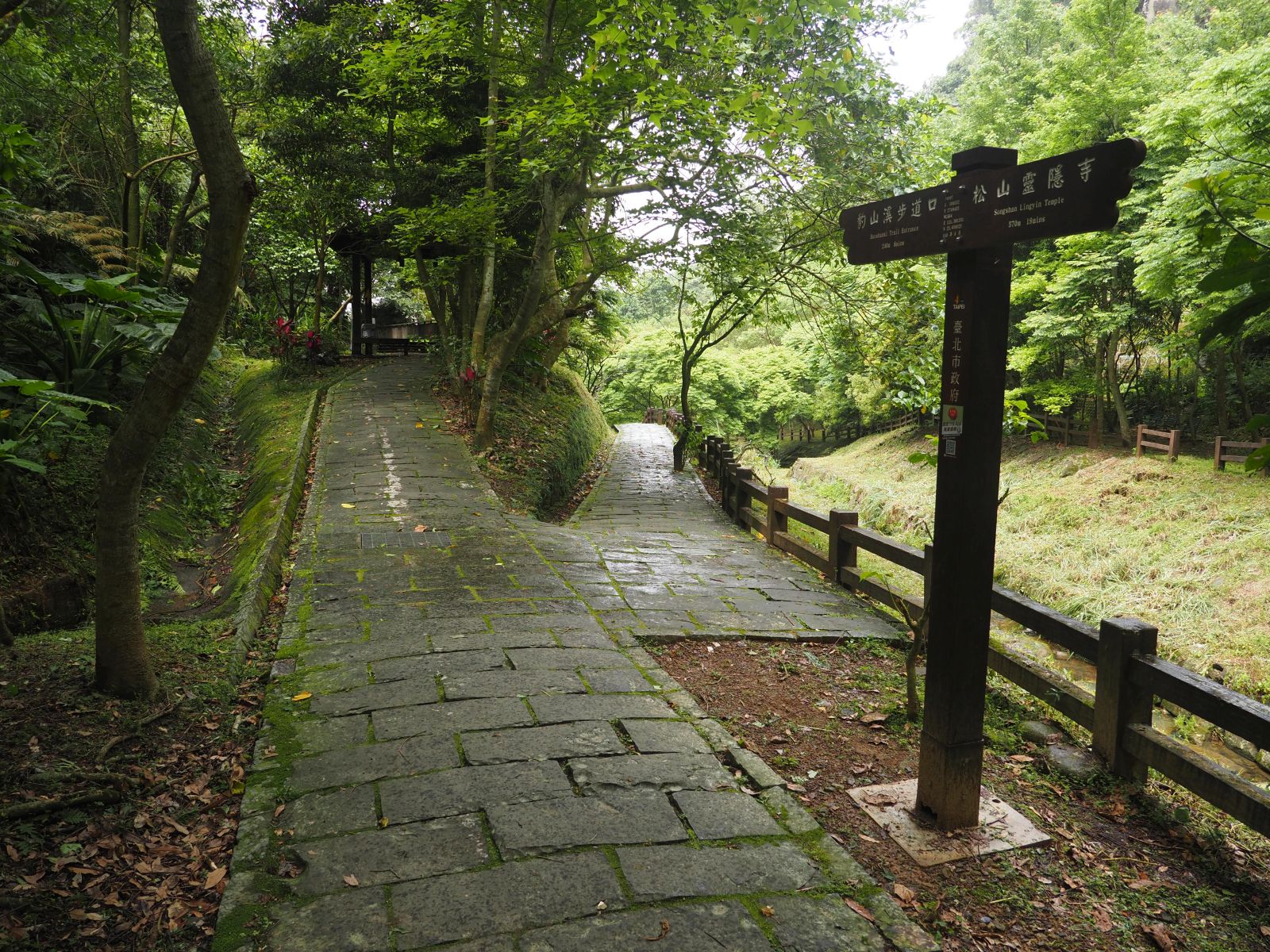
| Baoshanxi trail |
We feel drops of rain by now and hurry our further way down. This section of trail is pretty good like concrete pavement and hand rails all the way though much less travelled. We hit the official trail again in 10 minutes and take a right dirt trail down to Lingyin-si temple (靈隱寺). Baoshan-xi trail (豹山溪步道) starts just below the gate of the temple. It goes along the Baoshan-xi creek, which gets very narrow and deep like a gorge at one point. The walls of mountain open up again at 12:39 where a rest shelter stands. We have a final rest under the roof with beer!
 |
| Coming out of the gorge |
 |
| Yongchunpi Wetland park |
 |
| Retusus (流蘇) in full bloom |
We get down to Yongchunpi wetland park (永春埤生態濕池公園) and come out onto Fude road at 13:09. A #88 bus just comes by and I catch it with a hurried goodbye to friends, which gets me home in about a half hour. Nangangshan is indeed very close!!
We ended up hiking for 5 hours with a lot of rest. The distance was 7.6km with a total ascent of 397 meters and descent 439 meters. The route physical index was a mere 16, an easy hike after all.


0 件のコメント:
コメントを投稿