 |
| Looking south from the junction near Mt. Longlong |
最近一、二年は台湾の最東になる三貂角から南に延びる雪山山脈の最北端に人気がある。藍天隊が道を整理していることもあるが、登山人口が増えていることも関係しているだろう。
筆者が初めて訪れたのは、もう4年ほど前になるがその前に一度藍天隊が入り道整備をした。ところが、茅がすぐ生えてしまうこの稜線は、
その一年後に訪れた時はまた藪漕ぎの連続であった。そして二年ほど前に再度の道整備が行われた後は、人気がでてきたようだ。今年二月、藍天隊が雇った草刈業者が三貂角から登っていく萊萊山の尾根道を整理した。それが今回の訪問になった。実は二度ほど予定したが、天気が悪く延期し、今回も天気の心配をしての訪問だった。しかし、午前中は太陽がでる良い天気、午後から曇り下山の時は雨になった。すでに二度ほど訪れているので、英語で記述する。
 |
| @Mt. Longlong summit |
-----------------------------------------
Taiwan is an island of mountain kingdom. More than seventy percent of its terrain is covered with hills and mountains, and the highest peak, Mt. Yushan (玉山), stands highest in the East Asia. There are three major high mountain ranges running from north to south of the island, namely the Xueshan (雪山, Mt. Silvia) range, the Central Range and the Yushan (玉山) range, among which the Central Range is the longest of the three covering from Yilan (宜蘭) all the way down almost to the south tip of the island. Xueshan range is the second longest and it rises from the north eastern tip of the island, Sandiaojiao (三貂角) to near Taichong (台中), and its substantial part runs parallel to the Central Range.
 |
| Start from Sandiaojiao cape and get on the ridge |
 |
| Elevation profile |
The trip this time is to cover the very northern stretch of the Xueshan range, which we started from Sandiaojiao cape, the most northeast point of the island. A rather unpopular route on this section recently became very popular thanks to the continuous trail clearing work of Lantian (藍天) team, a volunteer hikers under the Taiwan Alpine Association (中華民國山岳協會 the official English name is Chinese Taipei Alpine Association). I first visited this section back in 2015 just after clearing work done by Lantian team. I visited again in 2016 and found that the trails were covered with overgrown vegetation, which gave us a hard time to walk through. Vegetation grows very fast in this subtropical island. Then last year the team hired a grass clearing company and kept trail maintenance, which made the trails of the section very good again.
 |
| Northeast end of Taiwan Island |
 |
| We alight #1740 bus at Magang bus stop |
The view from the trail over the ridge is spectacular if the weather is good. You can view the Pacific Ocean on the east and endless peaks in the south. If you look west, the town of Fulong (福隆) is down there by the ocean and mountains of Ruifang (瑞芳) beyond. We were really lucky to have a perfect weather on our this visit and enjoyed the great scenery. We got shower on our last leg down to Fulong, but we just needed to go through good old trails and paved road, which was no hustle at all.
 |
| Eastpoint Park |
 |
| Trail to the radar dome and light house |
We took a ride on #204 Zijianghao (自強號) express train to Shuangxi (雙溪) and then got on #1740 Guoguang (國光) bus. The train was a little behind schedule and we barely made it to the bus, which was just waiting in front of the station. Our bus travels through the valley of Gongliao (貢寮) and then pass by Fulong. It then rides by the ocean. A ride of a half hour takes us to Magang (馬崗) where we start our hike.
 |
| A view from the park |
 |
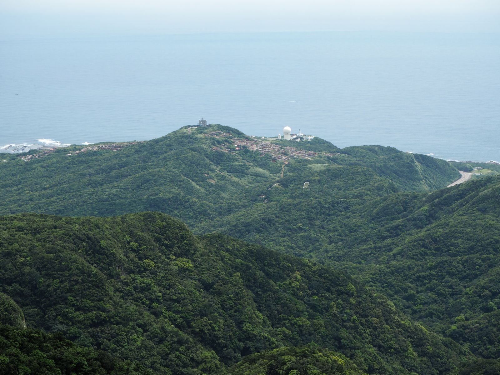
| Go through the cemetery |
Before starting our hike, we just go cross the road to visit Eastpoint park (極東公園), which denotes the east most point of the island. We come back to the hiking trail which leads to the platform where a light house and a big white radar dome stand. The trail, covered with concrete steps, goes up with moderate incline and brings us to the wide open platform in several minutes. The light house stands on the end of the platform and the rest part is a small park with stone sheep monuments and a pavilion on the other end. You can have a view of Magang fishing village and the blue Pacific Ocean beyond from the park.
 |
| Walk dirt road towards Mt. Lailai ridge |
The sky is clear and blue, which make us happy. The weather forecast on the day before stated a rather gloomy prospect. I had postponed this trip two times in the past due to the bad weather. I was concerned with possible rain, but this sky blows away my worry. We start off for the trail to Mt. Lailai (萊萊). We go through a big cemetery. There should be no other use of this hilly place except for gave yard but there is another factor why so many graves are here. Under the Chinese tradition, family graves are very important and believed to influence their descendants' fate. If the location of the grave is good, it brings prosperity to the family.
 |
| A narrow trail starts by the grave |
 |
| Junction with Fumao old trail |
We walk all the way to the end of the paved road which goes by the cemetery and take a dirt road. We go further onto the hill in front of us. There are still graves scattered here and there on the side of the road. There is a trail sign of Lantian team, which shows we are on the right track. We follow the trail to the place where a few graves stand side by side but no more trail ahead. We apparently miss some turns so we return to the point where we are sure. I find a marker ribbon tided on a branch over on the other side of a big grave. It is easy to overlook this marker unless you are very careful. We go around the grave and follow a narrow trail staring there.
 |
| Coming into the open grass field |
 |
| Going higher on the trail in the grass |
The trail now goes under trees. At 8:51 we come to a junction with Fumao (福卯古道) old trail. Our trail now goes on the sub ridge that extends from the main ridge near Mt. Longlong (隆隆山). In a few minutes from the junction, we come out of the woods and a nice view of the ocean and the green hills shows up behind us. The grasses of the trail are widely cut out, which was done by a grass clearing team in early March. If this clearing were not made, we would have had to swim in the tall grass field, which could be quite exhausting.
 |
| Guishandao is on the hirizon |
 |
| Trail under woods |
Higher we ascend, wider the scenery gets and the peaks of the main ridge including Mt. Longlong is coming closer on our right. The ocean on our left is very blue and the Island of
Guishandao (龜山島) is floating on it. We go into the woods again. By the time we come out of the woods, the peak of Mt. Lailai is just in front of us. We reach the peak at 10:10. There is no sign nor triangular stone post to show this is the summit, but the map shows it is. We keep on the ridge trail to a point where stand several small trees and have a rest in the small shade of the trees.
 |
| Keep going up on the trail |
 |
| The summit of Mt. Longlong |
 |
| The same peak 4 years ago (Nov. 2015) |
We pass over a few more small peaks and meet the trail of the main ridge at 10:33, where grasses are also widely trimmed and look very clean.
When I was here last time in three years ago, the trail is very narrow between thick and tall grasses. Following the nice trail on our right and we reach the summit of Mt. Longlong (433m in elevation) in a few minutes. The summit is also very widely cut out and presents a wonderful view, which was not available in the tall grasses last time. Now we can have 360 degree view. On west the gentle slope descents to the town of Fulong and the ocean. Further over the valley of Gongliao, peaks of Ruifang including
Mt. Cangguanliao (燦光寮山) and
Mt. Caoshan (草山) stand like a wall. On east the white light house where we have just started stands far below by the ocean.
 |
| Sandiaojiao light house and radar dome is far down by the ocean |
 |
| West side view, Fulong bay and mountains of Ruifang beyond |
 |
| Junction on the main ridge and peaks in the south |
 |
| Descend a steep slope with ropes |
We walk back to the junction and descend the steep slope for the next peak, Mt. Yinggeshi (鶯歌石山). If you look out, peaks of small and tall extends out one after another to the very far end. I have been to all these peaks in the past, including the well-known peaks like
Mt. Wankengtou (灣坑頭山) of Taoyuan valley (桃源谷). The trail is really in good shape. A few days of rain made the surface of the mad trail very slippery. The affixed ropes help us go down. Even if you slip, you just get your pants dirty by holding the rope. Passing another steep descend with ropes we go up again to Mt. Yinggeshi. The trail is wide and clean, really joy to walk on. We arrive at the peak of Mt. Yinggeshi (elevation 399m) at 11:26. The area of the summit is very widely cleared and the ocean is visible just down there over the cliff, which was not possible in the past We have lunch under trees.
 |
| View from the summit of Mt. Yinggeshi |
 |
| Look back the rock face of Mt. Yinggeshi |
The afternoon hike starts with another steep descend. At the bottom of the descend the rock face of Mt. Yinggeshi stands vertically and looks majestic. We were just on the top of it a short while ago. The trail follows ups and downs of the ridge, passing through grass open fields and woods alternately. We come down to the junction at 12:30 where a trail crosses. The trail from right is still OK, but the one to the left to the ocean looks pretty in bad shape, covered with grasses and bushes almost not passable. We go up again to Mt. Dakuaoshan (大堀澳山) and soon come out of the woods to a open grass field. The sky is getting cloudier and no more sunshine. The summit of the Mt. Dakuaoshan has no marking, just a triangular marker stone is on its top.
 |
| Look back Mr.Yinggeshi on the way up to Mt. Dakuaoshan |
 |
| Summit of Mt. Dakuaoshan, the peak behind is Mt. Shicheng |
We follow the trail and go down again and into the woods. When we come out of the woods on our way up, the summit of Mt. Shicheng (石城山) is not far. We arrive at it 13:05. There is no longer hot sun, so we just sit down on the grass and have a rest. The cloud is still high, and we can enjoy a nice view. From this angle, Gushadao really resembles a big turtle swimming in the ocean.
 |
| At the summit of Mt. Shicheng |
 |
| On the way down to Longling old trail pass |
 |
| Junction with Longling old trail |
 |
| A new sign post |
The descending trail soon goes under the woods and no more great view of the ocean. We reach the pass of Longling old trail (隆嶺古道) where a stone shrine of Tudigong deity (土地公) stands.
When I first visited this place several years ago, the shrine was collapsed and walls were laying flat. Later volunteers put them back and now it is a perfect shrine again. A new sign post is elected to indicate that this is a part of Danlan old trail (淡蘭古道). Originally I planed to continue our hike to another peak, Mt. Dahushan (大湖山), but the trail down from there may be not good as no new information of it is found. As soon as a direct descent from there via the old trail is decided, shower of rain starts. We put on rain ware or duck under an umbrella.
 |
| Cross the stream and walk on its right bank |
 |
| walk on the old trail in rain |
The old trail is in good shape. We run into two young men coming up on the trail, who are the only other hikers we have met today. The first section of the old trail ends soon and a paved road goes down for a few minutes. Another section of the old trail starts on the right side of the paved road. We take it and go down to a stream and cross it. The trail goes on the right side of the stream. Some part is covered by grasses and my pants get wet of rain drops. The bottom section of the trail ends in about twenty minutes and we come back on the paved road, which runs parallel to the old trail. We continue on the road and come to a park beside the old Caoling railway tunnel (舊草嶺隧道) which was replaced by the new double truck tunnel.
 |
| The park by the old Cailing tunnel with a memorial stone |
 |
| Fulong station |
The last leg of the hike is a few kilometers of road walk. It is still raining but does not matter. We reach Fulong station 15:45, completing our hike. We walked 13 kilometers in about 8 hours including rests. The total ascent is 750m. The trails here over open grass fields offer great view when the weather is fine. But it can be very hot under the ruthless sun of summer. I recommend to go there in spring or fall. I hope that the trails can be kept in good condition like this time and many hikers can enjoy it.


このコメントは投稿者によって削除されました。
返信削除